|
search place name
|
||
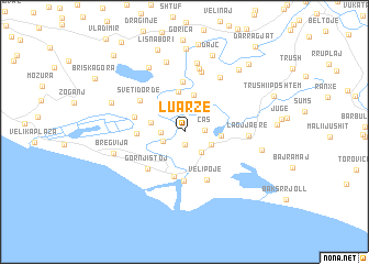
Luarzë (Shkodër, Albania)Luarzë is a town in the Shkodër region of Albania. An overview map of the region around Luarzë is displayed below.
regional and 3d topo map of Luarzë, Albania ::
Luarzë airports ::
The nearest airport is TGD - Podgorica, located 49.8 km north of Luarzë.
Other airports nearby include TIA - Tirana Rinas (62.9 km south east), TIV - Tivat (76.6 km north west), DBV - Dubrovnik (116.4 km north west), OHD - Ohrid (140.1 km south east), Nearby towns ::
Reçi i Ri (1.3km south) //
Ças (1.5km east) //
Reç (1.9km south west) //
Reč (1.8km west) //
Mblsukë (2.4km south east) //
Gomsiqja e Re (2.4km south east) //
Markcokaj (3.4km north east) //
Sutjel (2.7km west) //
Baks i Ri (2.8km east) //
Mali i Gjymtit (3.8km north) //
Pentar (4.1km north) //
Sveti Nikola (4.6km south) //
Kodra Dake (3.7km west) //
Pulaj (5.0km south) //
Fraskanjel (5.0km north) //
Ćurke (4.1km west) //
Gornji Štoj (4.7km south west) //
Velipojë (5.1km south) //
Sveti Ðorđe (4.6km north west) //
Belaj (6.2km north) //
Lagjja e Re (4.9km east) //
Rrushkull (6.5km north) //
Suk-Dajç (6.1km north east) //
Samrisht i Ri (7.1km north) //
Štodra (7.2km north) //
Ambula (7.0km north) //
Bregvija (5.8km west) //
Darza (6.3km north west) //
Mali Kolaj (6.2km east) //
[all distances 'as the bird flies' and approximate]  Places with similar names to Luarzë, Albania ::
Disclaimer :: Information on this page comes without warranty of any kind |
||
|
Where is Luarzë? Elevation and coordinates ::
Latitude (lat): 41°55'19"N Longitude (lon): 19°23'6"E
Elevation (approx.): 16m (map arrows pan, magnifying glasses zoom) |
||
|
Visiting Luarzë? Hotel/Accommodation ::
Book a hotel in Luarzë Travel Guide ::
Buy a travel guide for Albania rental cars ::
car rental offers GPS waypoint ::
download a GPX waypoint (PoI) of Luarzë for your GPS receiver
|
||