|
search place name
|
||
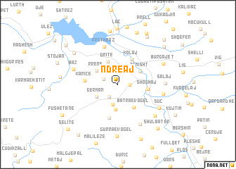
Ndreaj (Dibër, Albania)Ndreaj is a town in the Dibër region of Albania. An overview map of the region around Ndreaj is displayed below.
regional and 3d topo map of Ndreaj, Albania ::
Ndreaj airports ::
The nearest airport is TIA - Tirana Rinas, located 31.4 km south west of Ndreaj.
Other airports nearby include OHD - Ohrid (78.8 km south east), TGD - Podgorica (103.4 km north west), TIV - Tivat (137.3 km north west), PRN - Pristina (137.4 km north east), Nearby towns ::
Burrel (1.3km east) //
Midhë (2.2km south west) //
Kodërçere (1.9km north west) //
Kombësi (3.2km south) //
Gërman (3.2km south west) //
Batra e Madhe (4.0km south) //
Dritë (3.9km north) //
Rrenë (3.4km north west) //
Zenisht (3.4km north east) //
Batra e Vogël (4.0km south east) //
Kolaj (4.3km north east) //
Shoshaj (3.6km east) //
Karicë (4.0km west) //
Frankth (5.3km south) //
Rreth-Baz (6.2km north) //
Rripë (6.9km south) //
Mallunxë (5.6km east) //
Baz (5.8km north west) //
Suç (6.1km south east) //
Salaj (5.6km east) //
Dom (6.6km south east) //
Burgajet (6.3km north east) //
Gurra e Vogël (8.2km south) //
Urakë (8.5km north) //
Blat (7.2km north west) //
Rukaj (8.4km north) //
Rremull (8.3km north east) //
Laç (8.9km north) //
Zmaç (8.8km north east) //
[all distances 'as the bird flies' and approximate] 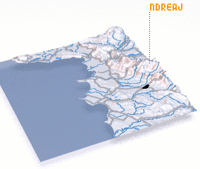
Disclaimer :: Information on this page comes without warranty of any kind |
||
|
Where is Ndreaj? Elevation and coordinates ::
Latitude (lat): 41°36'37"N Longitude (lon): 19°59'34"E
Elevation (approx.): 223m (map arrows pan, magnifying glasses zoom) |
||
|
Visiting Ndreaj? Hotel/Accommodation ::
Book a hotel in Ndreaj Travel Guide ::
Buy a travel guide for Albania rental cars ::
car rental offers GPS waypoint ::
download a GPX waypoint (PoI) of Ndreaj for your GPS receiver
|
||