|
search place name
|
||
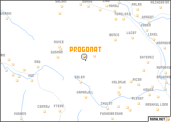
Progonat (Gjirokastër, Albania)Progonat is a town in the Gjirokastër region of Albania. An overview map of the region around Progonat is displayed below.
regional and 3d topo map of Progonat, Albania ::
Progonat airports ::
The nearest airport is CFU - Kerkyra/corfu Ioannis Kapodistrias Intl, located 67.9 km south of Progonat.
Other airports nearby include IOA - Ioannina (94.4 km south east), KSO - Kastoria Aristotelis (116.6 km east), OHD - Ohrid (126.8 km north east), TIA - Tirana Rinas (134.8 km north), Nearby towns ::
Lekdush (1.8km north east) //
Golem (4.7km south) //
Rexhin (4.9km north west) //
Gusmar (4.7km west) //
Nivicë (5.3km north west) //
Kaparjel (7.9km south) //
Bënçë (6.8km north east) //
Kolonjë (8.1km south east) //
Kiknesh (8.8km south east) //
Linat (9.3km south east) //
[all distances 'as the bird flies' and approximate]  Places with similar names to Progonat, Albania ::
Disclaimer :: Information on this page comes without warranty of any kind |
||
|
Where is Progonat? Elevation and coordinates ::
Latitude (lat): 40°12'48"N Longitude (lon): 19°56'41"E
Elevation (approx.): 926m (map arrows pan, magnifying glasses zoom) |
||
|
Visiting Progonat? Hotel/Accommodation ::
Book a hotel in Progonat Travel Guide ::
Buy a travel guide for Albania rental cars ::
car rental offers GPS waypoint ::
download a GPX waypoint (PoI) of Progonat for your GPS receiver
|
||