|
search place name
|
||
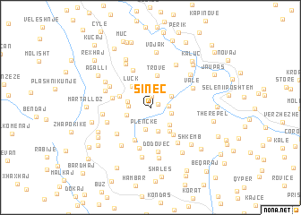
Sinec (Berat, Albania)Sinec is a town in the Berat region of Albania. An overview map of the region around Sinec is displayed below.
regional and 3d topo map of Sinec, Albania ::
Sinec airports ::
The nearest airport is OHD - Ohrid, located 91.6 km north east of Sinec.
Other airports nearby include TIA - Tirana Rinas (101.4 km north), KSO - Kastoria Aristotelis (104.2 km east), CFU - Kerkyra/corfu Ioannis Kapodistrias Intl (104.8 km south), IOA - Ioannina (113.9 km south east), Nearby towns ::
Fushtan (0.8km north east) //
Tozhar (1.5km north) //
Palec (1.7km east) //
Vizhar (2.1km east) //
Plënckë (2.8km south) //
Paraspuar (2.1km west) //
Dollan (2.8km north) //
Sinaj (2.4km north east) //
Veliaj (2.3km west) //
Vokopolë (2.9km south) //
Dokaj (2.4km west) //
Sylet (2.8km south east) //
Luçk (3.2km north west) //
Gerdan (3.4km south east) //
Trove (4.0km north) //
Tërpan (3.3km north west) //
Meçaj (4.0km south east) //
Gumë (4.3km south) //
Dyrmishaj (3.8km west) //
Teman (5.0km north) //
Barmë (5.2km south) //
Lekër (4.6km south west) //
Goran (5.1km south east) //
Dodovec (5.5km south) //
Lilaj (4.7km north west) //
Agallinj (4.5km south west) //
Valë (4.7km north east) //
Panarit (5.5km south west) //
Demiraj (4.8km north west) //
[all distances 'as the bird flies' and approximate]  Places with similar names to Sinec, Albania ::
Disclaimer :: Information on this page comes without warranty of any kind |
||
|
Where is Sinec? Elevation and coordinates ::
Latitude (lat): 40°32'20"N Longitude (lon): 20°3'34"E
Elevation (approx.): 391m (map arrows pan, magnifying glasses zoom) |
||
|
Visiting Sinec? Hotel/Accommodation ::
Book a hotel in Sinec Travel Guide ::
Buy a travel guide for Albania rental cars ::
car rental offers GPS waypoint ::
download a GPX waypoint (PoI) of Sinec for your GPS receiver
|
||