|
search place name
|
||
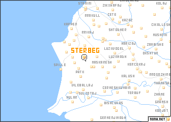
Stërbeg (Durrës, Albania)Stërbeg is a town in the Durrës region of Albania. An overview map of the region around Stërbeg is displayed below.
regional and 3d topo map of Stërbeg, Albania ::
Stërbeg airports ::
The nearest airport is TIA - Tirana Rinas, located 37.8 km north east of Stërbeg.
Other airports nearby include OHD - Ohrid (103.2 km east), TGD - Podgorica (140.4 km north), BDS - Brindisi Casale (141.6 km west), LCC - Lecce (151.9 km south west), Nearby towns ::
Kryevidh (1.5km south east) //
Sharrëdushk (1.9km south west) //
(( Ballaj i Ri )) (1.9km south east) //
Spanesh (1.9km west) //
Beden (2.1km north east) //
Kazi (2.4km west) //
Hajdaraj (3.5km north) //
Patk (3.4km south) //
(( Maskaresh )) (3.0km south east) //
Domën (3.8km north west) //
Peqinaj (4.6km north west) //
(( Hallula )) (4.9km north west) //
Rrikaj (5.4km north) //
(( Zashtik )) (4.4km south east) //
Rreth-Greth (5.2km south west) //
(( Dautaj )) (5.1km north east) //
Spille (4.5km south west) //
Zhabjak (5.0km south east) //
Bago (6.0km north) //
Vilë-Ballaj (6.2km south) //
Blerimaj (5.7km north east) //
(( Ballutaj )) (5.6km north east) //
Bardhor (5.5km north west) //
Shkozet (4.9km east) //
Vorrozen (5.5km north east) //
Luzi i Vogël (5.1km east) //
(( Bashtovë )) (7.0km south) //
Luzi i Madh (5.4km east) //
(( Shelk )) (7.2km south) //
[all distances 'as the bird flies' and approximate]  Places with similar names to Stërbeg, Albania ::
// Staryy Byk (RU)
// Strebki (RU)
// Strebki (RU)
// Storbeck (DE)
// Storbeck (DE)
// Ströbeck (DE)
// Strebeikiai (LT)
// Stërbeq (AL)
// Štrbac (BA)
// Starbuck (US)
Disclaimer :: Information on this page comes without warranty of any kind |
||
|
Where is Stërbeg? Elevation and coordinates ::
Latitude (lat): 41°6'41"N Longitude (lon): 19°31'1"E
Elevation (approx.): 138m (map arrows pan, magnifying glasses zoom) |
||
|
Visiting Stërbeg? Hotel/Accommodation ::
Book a hotel in Stërbeg Travel Guide ::
Buy a travel guide for Albania rental cars ::
car rental offers GPS waypoint ::
download a GPX waypoint (PoI) of Stërbeg for your GPS receiver
|
||