|
search place name
|
||
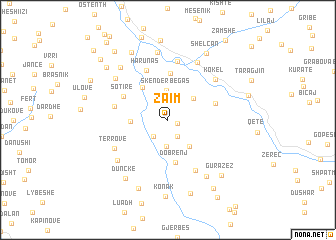
Zaim (Elbasan, Albania)Zaim is a town in the Elbasan region of Albania. An overview map of the region around Zaim is displayed below.
regional and 3d topo map of Zaim, Albania ::
Zaim airports ::
The nearest airport is OHD - Ohrid, located 63.9 km north east of Zaim.
Other airports nearby include TIA - Tirana Rinas (86.1 km north west), KSO - Kastoria Aristotelis (94.2 km east), IOA - Ioannina (126.7 km south east), CFU - Kerkyra/corfu Ioannis Kapodistrias Intl (130.2 km south), Nearby towns ::
Ermenj (0.9km south east) //
Vidhan (2.0km south east) //
Kotkë (2.2km south west) //
Lemnushë (2.9km south) //
Skënderbegas (3.2km north) //
Bletëz (3.2km north east) //
Siman (3.4km south east) //
Kërpicë (3.1km west) //
Kapillanas (4.2km north west) //
Dobrenj (4.8km south) //
Zenelas (5.2km north) //
Sotirë (4.6km north west) //
Kullollas (4.5km north east) //
Harunas (5.8km north) //
Marish (4.8km west) //
Burranj (6.1km south) //
Kodovjat (6.6km north) //
Tërrovë (5.5km south west) //
Kokël (6.0km north east) //
Bulçar (6.9km north) //
Rromas (6.2km south west) //
Kushovë (6.4km north west) //
Bërsnik (7.6km north) //
Çorrotat (7.1km south east) //
Bregas (7.1km north west) //
Dunckë (7.4km south west) //
Trebël (8.1km south) //
Nartë (8.1km north) //
Shelcan (8.1km north east) //
[all distances 'as the bird flies' and approximate] 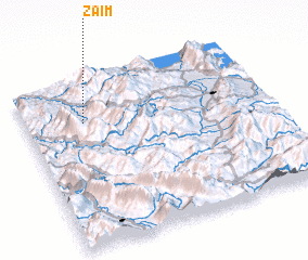 Places with similar names to Zaim, Albania ::
Disclaimer :: Information on this page comes without warranty of any kind |
||
|
Where is Zaim? Elevation and coordinates ::
Latitude (lat): 40°44'49"N Longitude (lon): 20°14'30"E
Elevation (approx.): 616m (map arrows pan, magnifying glasses zoom) |
||
|
Visiting Zaim? Hotel/Accommodation ::
Book a hotel in Zaim Travel Guide ::
Buy a travel guide for Albania rental cars ::
car rental offers GPS waypoint ::
download a GPX waypoint (PoI) of Zaim for your GPS receiver
|
||