|
search place name
|
||
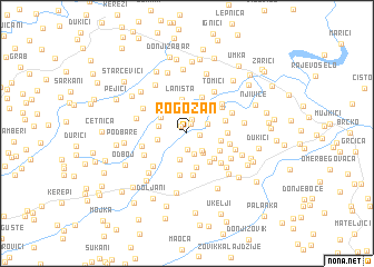
Rogozan (Bosnia and Herzegovina)Rogozan is a town in Bosnia and Herzegovina. An overview map of the region around Rogozan is displayed below.
regional and 3d topo map of Rogozan, Bosnia and Herzegovina ::
Rogozan airports ::
The nearest airport is OSI - Osijek, located 66.6 km north of Rogozan.
Other airports nearby include SJJ - Sarajevo (119.4 km south), BEG - Beograd (130.4 km east), OMO - Mostar (188.3 km south), Nearby towns ::
Žepce (0.8km north west) //
VukšićGornji (1.0km north) //
Purići (0.9km east) //
Martinovići (1.5km north) //
Poljani (1.6km south) //
Pejići (2.1km south) //
Brezje (2.0km south east) //
Ulice (1.8km north east) //
Babići (2.3km south east) //
Savići (2.7km south) //
Bare (2.6km north east) //
Bašče (2.2km west) //
Jagodnjak (2.2km west) //
Endek (2.5km north west) //
Laništa (3.4km north) //
Pejini (2.5km east) //
Vitanovići Gornji (3.5km south) //
Gornja Laništa (3.4km north west) //
VitanovićiDonji (3.3km south east) //
Grgići (3.1km south east) //
Purići (2.9km south east) //
Donja Laništa (3.7km north) //
Ugara (3.0km north east) //
Lukići (2.9km east) //
Pajići (4.2km south) //
Bukvik Donji (4.2km south) //
Tinjasi (3.6km north east) //
Bajići (3.2km east) //
Vasiljevići (3.8km south east) //
[all distances 'as the bird flies' and approximate]  Places with similar names to Rogozan, Bosnia and Herzegovina ::
Disclaimer :: Information on this page comes without warranty of any kind |
||
|
Where is Rogozan? Elevation and coordinates ::
Latitude (lat): 44°52'22"N Longitude (lon): 18°39'41"E
Elevation (approx.): 98m (map arrows pan, magnifying glasses zoom) |
||
|
Visiting Rogozan? Hotel/Accommodation ::
Book a hotel in Rogozan Travel Guide ::
rental cars ::
car rental offers GPS waypoint ::
download a GPX waypoint (PoI) of Rogozan for your GPS receiver
|
||