|
search place name
|
||
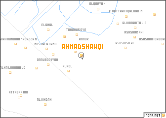
Aḩmad Shawqī (Al Buḩayrah, Egypt)Aḩmad Shawqī is a town in the Al Buḩayrah region of Egypt. An overview map of the region around Aḩmad Shawqī is displayed below.
regional and 3d topo map of Aḩmad Shawqī, Egypt ::
Aḩmad Shawqī airports ::
The nearest airport is ALY - Alexandria Intl, located 59.5 km north of Aḩmad Shawqī.
Other airports nearby include CAI - Cairo Intl (135.7 km south east), Nearby towns ::
Abū Bakr aş Şiddīq (2.2km north west) //
Sa‘d Zaghlūl (3.0km north east) //
An Nūr (3.4km north) //
Al ‘Adl (4.0km south west) //
Ţaha Ḩusayn (5.7km north) //
‘Abd al ‘Az̧īm Abū al ‘Aţā (6.2km north west) //
‘Uthmān Muḩarram (5.9km west) //
An Nūbārīyah (6.9km west) //
Muşţafá Kāmil (7.4km west) //
El-Amal (9.5km north west) //
Al Amal (9.5km north west) //
‘Abbās al ‘Aqqād (10.5km north east) //
[all distances 'as the bird flies' and approximate]  Places with similar names to Aḩmad Shawqī, Egypt ::
Disclaimer :: Information on this page comes without warranty of any kind |
||
|
Where is Aḩmad Shawqī? Elevation and coordinates ::
Latitude (lat): 30°40'30"N Longitude (lon): 30°8'45"E
Elevation (approx.): 22m (map arrows pan, magnifying glasses zoom) |
||
|
Visiting Aḩmad Shawqī? Hotel/Accommodation ::
Book a hotel in Aḩmad Shawqī Travel Guide ::
Buy a travel guide for Egypt rental cars ::
car rental offers GPS waypoint ::
download a GPX waypoint (PoI) of Aḩmad Shawqī for your GPS receiver
|
||