|
search place name
|
||
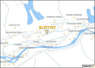
Al ‘Aţīyāt (Qinā, Egypt)Al ‘Aţīyāt is a town in the Qinā region of Egypt. An overview map of the region around Al ‘Aţīyāt is displayed below.
regional and 3d topo map of Al ‘Aţīyāt, Egypt ::
Al ‘Aţīyāt airports ::
The nearest airport is LXR - Luxor Intl, located 57.7 km south of Al ‘Aţīyāt.
Other airports nearby include HRG - Hurghada Intl (171.5 km north east), Nearby towns ::
Naj‘ al Qunburah (0.7km west) //
Al ‘Izab (0.9km north west) //
Naj‘ al Fāwīyah (1.5km west) //
Naj‘ al Gharābwah al Baḩrī (1.7km north east) //
Abū Mannā‘ Qiblī (2.6km west) //
Naj‘ al Ḩarājīyah (2.9km north east) //
Naj‘ al Ḩajarīyah (3.3km west) //
Abū Mannā‘ Sharq (3.8km west) //
Naj‘ Samrah (4.3km south) //
Naj‘ Awlād Jābir (5.1km south east) //
Wādī Kawlat Abū Laylah (5.2km north east) //
As Samaţā (5.6km south east) //
Abū Dhiʼāb (5.4km north east) //
Dishnā (5.7km south west) //
Wadī az Zanbaqah (6.1km north east) //
Naj‘ al ‘Arab (6.2km south) //
Al Ḩujayrāt (5.9km east) //
Abū Diyāb Sharq (6.6km north east) //
Al Marāshidah (7.4km south) //
Abū Mannā‘ Gharb (6.9km west) //
Al Ghawaşah (7.6km east) //
Aş Şabrīyāt (8.6km south west) //
Naj‘ al Kasārinah (9.6km south west) //
Al Waqf (11.1km south west) //
[all distances 'as the bird flies' and approximate] 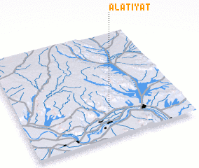 Places with similar names to Al ‘Aţīyāt, Egypt ::
// AL ‘Aţīyāt (EG)
Disclaimer :: Information on this page comes without warranty of any kind |
||
|
Where is Al ‘Aţīyāt? Elevation and coordinates ::
Latitude (lat): 26°9'32"N Longitude (lon): 32°30'13"E
Elevation (approx.): 75m (map arrows pan, magnifying glasses zoom) |
||
|
Visiting Al ‘Aţīyāt? Hotel/Accommodation ::
Book a hotel in Al ‘Aţīyāt Travel Guide ::
Buy a travel guide for Egypt rental cars ::
car rental offers GPS waypoint ::
download a GPX waypoint (PoI) of Al ‘Aţīyāt for your GPS receiver
|
||