|
search place name
|
||
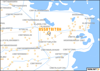
As Satāʼitah (Ad Daqahlīyah, Egypt)As Satāʼitah is a town in the Ad Daqahlīyah region of Egypt. An overview map of the region around As Satāʼitah is displayed below.
regional and 3d topo map of As Satāʼitah, Egypt ::
As Satāʼitah airports ::
The nearest airport is PSD - Port Said, located 35.4 km north east of As Satāʼitah.
Other airports nearby include CAI - Cairo Intl (123.4 km south west), ALY - Alexandria Intl (186.0 km west), Nearby towns ::
Mīt Khuḑayr (1.1km north west) //
Al ‘Āmirah (1.2km south east) //
Kafr Ḩajjāj (1.2km west) //
‘Izbat aţ Ţāhirī (1.4km south west) //
Judayyidat al Manzilah (1.7km east) //
Al Furūsāt (1.8km east) //
Al Mawājid (2.3km north west) //
Al Buşrāţ (2.9km north west) //
‘Izbat aţ Ţūbijīyah (3.3km south) //
Al Biţānīyah (3.5km south) //
‘Izbat ar Rawḑah (3.3km south west) //
‘Izbat ‘Alī Zakī (4.0km south west) //
Mīt Sharīf (3.7km north west) //
Al Manzilah (3.6km east) //
‘Izbat al Gharābiwah (4.1km south west) //
Al Jamālīyah (4.7km north west) //
‘Izbat al ‘Abbāsīyah (5.0km south west) //
‘Izbat Abū al Akhḑar (6.3km south) //
‘Izbat aş Şāyit (6.0km south west) //
Mīt Murajjah Salsīl (6.3km north west) //
Al Qurmah (6.2km west) //
Awlād Ḩānah (6.3km east) //
Al Kafr al Jadīd (6.6km west) //
‘Izbat Muḩammad al Waşīfī (7.0km north west) //
‘Izbat al Ja‘āfrah (6.8km south west) //
‘Izbat al Hanāydah (6.7km east) //
‘Izbat ar Rub‘umāyah (6.7km west) //
Banī Hilāl (6.8km north east) //
‘Izbat aţ Ţawābirah (6.7km east) //
[all distances 'as the bird flies' and approximate] 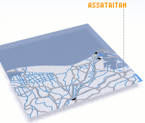 Places with similar names to As Satāʼitah, Egypt ::
Disclaimer :: Information on this page comes without warranty of any kind |
||
|
Where is As Satāʼitah? Elevation and coordinates ::
Latitude (lat): 31°9'0"N Longitude (lon): 31°54'0"E
Elevation (approx.): 3m (map arrows pan, magnifying glasses zoom) |
||
|
Visiting As Satāʼitah? Hotel/Accommodation ::
Book a hotel in As Satāʼitah Travel Guide ::
Buy a travel guide for Egypt rental cars ::
car rental offers GPS waypoint ::
download a GPX waypoint (PoI) of As Satāʼitah for your GPS receiver
|
||