|
search place name
|
||
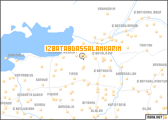
‘Izbat ‘Abd as Salām Karīm (Al Fayyūm, Egypt)‘Izbat ‘Abd as Salām Karīm is a town in the Al Fayyūm region of Egypt. An overview map of the region around ‘Izbat ‘Abd as Salām Karīm is displayed below.
regional and 3d topo map of ‘Izbat ‘Abd as Salām Karīm, Egypt ::
‘Izbat ‘Abd as Salām Karīm airports ::
The nearest airport is CAI - Cairo Intl, located 91.2 km north east of ‘Izbat ‘Abd as Salām Karīm.
Other airports nearby include ALY - Alexandria Intl (209.1 km north west), PSD - Port Said (242.1 km north east), Nearby towns ::
‘Izbat Muḩammad Jūdah (0.9km north east) //
‘Izbat ash Shawbak (1.5km south) //
‘Izbat zayid Abū Shu‘ayb (1.9km south) //
‘Izbat ‘Abd as Salām ad Dīdānī (1.8km north west) //
‘Izbat Abū Su‘ād (2.2km east) //
‘Izbat ‘Abd ar Raḩmān ar Rāghī (3.8km north) //
Minshaʼat Banī ‘Uthmān (3.6km east) //
‘Izbat al ‘Arīf (3.8km east) //
Abhīt (4.5km south) //
‘Izbat Ḩusayn Abū Shannāf (4.0km east) //
‘Izbat al Barm (4.2km north east) //
Minshaʼat as Sādāt (4.1km west) //
Tirsā (4.6km south west) //
‘Izbat ‘Abd al ‘Az̧īm (4.5km north east) //
Az Zāwiyah al Khaḑrāʼ (5.3km south) //
As Sa‘īdīyah (4.9km south west) //
Az Zāwiyah al Khaḑrāʼ (5.5km south) //
‘Izbat Manşūr (5.5km north) //
‘Izbat Ḩusnī (5.2km south east) //
Kafr Fazārah (5.7km south west) //
Dawwār Jabal (5.2km east) //
Sinnūris (5.8km south east) //
‘Izbat aţ Ţaḩūn (5.7km north east) //
‘Izbat aş Şabāḩīyah (5.2km east) //
‘Izbat Muḩammad Yūsif (5.4km west) //
‘Izbat Mukhaymar Yūsif (6.1km west) //
Jarfis (6.9km south east) //
‘Izbat Abū Na‘ūrah (6.9km south west) //
‘Izbat al Aşfar (7.1km north east) //
[all distances 'as the bird flies' and approximate]  Places with similar names to ‘Izbat ‘Abd as Salām Karīm, Egypt :: Disclaimer :: Information on this page comes without warranty of any kind |
||
|
Where is ‘Izbat ‘Abd as Salām Karīm? Elevation and coordinates ::
Latitude (lat): 29°27'49"N Longitude (lon): 30°50'26"E
Elevation (approx.): -37m (map arrows pan, magnifying glasses zoom) |
||
|
Visiting ‘Izbat ‘Abd as Salām Karīm? Hotel/Accommodation ::
Book a hotel in ‘Izbat ‘Abd as Salām Karīm Travel Guide ::
Buy a travel guide for Egypt rental cars ::
car rental offers GPS waypoint ::
download a GPX waypoint (PoI) of ‘Izbat ‘Abd as Salām Karīm for your GPS receiver
|
||