|
search place name
|
||
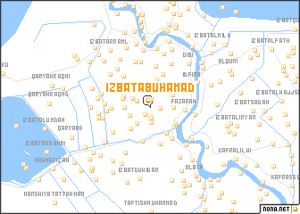
‘Izbat Abū Ḩamad (Al Buḩayrah, Egypt)‘Izbat Abū Ḩamad is a town in the Al Buḩayrah region of Egypt. An overview map of the region around ‘Izbat Abū Ḩamad is displayed below.
regional and 3d topo map of ‘Izbat Abū Ḩamad, Egypt ::
‘Izbat Abū Ḩamad airports ::
The nearest airport is ALY - Alexandria Intl, located 50.0 km west of ‘Izbat Abū Ḩamad.
Other airports nearby include CAI - Cairo Intl (155.7 km south east), PSD - Port Said (169.1 km east), Nearby towns ::
‘Izbat Badr (1.0km north) //
‘Izbat Thābit Thābit (1.1km south west) //
‘Izbat Ghallāb (1.2km south) //
‘Izbat Manshīyat ‘Ilwān Raqm 1 (1.1km east) //
Manshīyat ‘Ilwān Raqm 5 (1.4km south) //
‘Izbat Aḩmad Abū ar Riḑá (1.6km north west) //
‘Izbat Khālid Mar‘ī (2.0km north) //
Niz̧ārat Sīdī ‘Uqbá (2.0km south) //
‘Izbat Maştā al Kubrá (2.1km north west) //
‘Izbat Sīdī ‘Uqbah (2.5km south west) //
‘Izbat as Sa‘dāwī (2.4km south west) //
‘Izbat Maştā Kawm 3 (2.7km north west) //
Manshīyat ‘Ilwān (2.5km east) //
‘Izbat Khayr Allāh (2.7km west) //
‘Izbat al ‘Āmirīyah ash Sharqīyah Raqm 2 (2.9km north east) //
‘Izbat al ‘Ittah (3.2km north west) //
‘Izbat Aḩmad Abū Rukbah (3.1km north west) //
Al Ghābishah (3.5km north) //
‘Izbat Manshīyat Ismā‘īl ‘Aţīyah (3.1km west) //
‘Izbat al Kawm (3.4km north west) //
‘Izbat ‘Abd al ‘Azīz (3.4km south west) //
Minyat as Sa‘īd (3.4km south east) //
‘Izbat ash Shāfi‘ī al Labbān (3.7km south east) //
‘Izbat al ‘Arab (3.6km south east) //
Taftîsh Idfîna (4.3km north) //
Fazārah (3.7km east) //
‘Izbat 16 (4.4km south) //
‘Izbat S‘ad al Labbān (4.6km south east) //
‘Izbat al Ḩajar (4.8km south) //
[all distances 'as the bird flies' and approximate]  Places with similar names to ‘Izbat Abū Ḩamad, Egypt ::
// ‘Izbat Abū Ḩammūdah (EG)
Disclaimer :: Information on this page comes without warranty of any kind |
||
|
Where is ‘Izbat Abū Ḩamad? Elevation and coordinates ::
Latitude (lat): 31°16'3"N Longitude (lon): 30°27'53"E
Elevation (approx.): 1m (map arrows pan, magnifying glasses zoom) |
||
|
Visiting ‘Izbat Abū Ḩamad? Hotel/Accommodation ::
Book a hotel in ‘Izbat Abū Ḩamad Travel Guide ::
Buy a travel guide for Egypt rental cars ::
car rental offers GPS waypoint ::
download a GPX waypoint (PoI) of ‘Izbat Abū Ḩamad for your GPS receiver
|
||