|
search place name
|
||
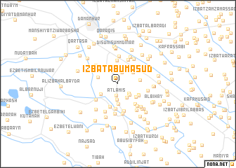
‘Izbat Abū Mas‘ūd (Al Buḩayrah, Egypt)‘Izbat Abū Mas‘ūd is a town in the Al Buḩayrah region of Egypt. An overview map of the region around ‘Izbat Abū Mas‘ūd is displayed below.
regional and 3d topo map of ‘Izbat Abū Mas‘ūd, Egypt ::
‘Izbat Abū Mas‘ūd airports ::
The nearest airport is ALY - Alexandria Intl, located 59.4 km north west of ‘Izbat Abū Mas‘ūd.
Other airports nearby include CAI - Cairo Intl (125.7 km south east), PSD - Port Said (169.3 km east), Nearby towns ::
Aţlamīs (1.8km south) //
‘Izbat as Sawwāḩīn (1.9km north) //
‘Izbat Barānis al Ḩajar (2.1km south east) //
‘Izbat Ḩabash Ḩannā (2.4km south east) //
‘Izbat Yūsif ash Sharnūbī (2.5km south) //
‘Izbat Ismā‘īl ‘Abd al Qādir (2.4km south east) //
Dinshāl (2.8km north east) //
‘Izbat Nādir (3.2km south) //
Abū Ḩimār al Kabīr (2.9km south west) //
Al ‘Awjāʼ (2.9km north east) //
‘Izbat Aḩmad Ismā‘īl (3.1km north east) //
Al Manshīyah al Ibrāhīmīyah (2.9km west) //
‘Izbat ad Daramallī al Qiblīyah (3.2km south east) //
Ar Rawaqah (3.1km east) //
‘Izbat ad Daramallī al Baḩarīyah (3.3km south east) //
Minyat ‘Aţīyah (3.7km north) //
‘Izbat Shubrā an Nūnah ash Sharqīyah (3.4km south east) //
Naj‘ Rashīd Mihannā (3.8km south) //
‘Izbat al ‘Awwāmah al Gharbīyah (3.9km south) //
Qaryat Nāşir (4.1km north) //
‘Izbat Maḩmūd ash Shinnāwī (3.9km south east) //
Naj‘ Muḩammad Fāḑīl (3.9km south west) //
Al Misīn (4.4km south) //
‘Izbat Dāwūd an Najjār (4.4km north) //
Sunţays (4.3km north west) //
‘Izbat Maḩmūd al Mardūshī (4.6km north) //
‘Izbat Sayyid Aḩmad ash Shinnāwī (4.4km south east) //
‘Izbat al Fatayānī (4.6km north east) //
‘Izbat al Ḩusaynī (4.7km south) //
[all distances 'as the bird flies' and approximate]  Places with similar names to ‘Izbat Abū Mas‘ūd, Egypt :: Disclaimer :: Information on this page comes without warranty of any kind |
||
|
Where is ‘Izbat Abū Mas‘ūd? Elevation and coordinates ::
Latitude (lat): 30°56'52"N Longitude (lon): 30°30'29"E
Elevation (approx.): 9m (map arrows pan, magnifying glasses zoom) |
||
|
Visiting ‘Izbat Abū Mas‘ūd? Hotel/Accommodation ::
Book a hotel in ‘Izbat Abū Mas‘ūd Travel Guide ::
Buy a travel guide for Egypt rental cars ::
car rental offers GPS waypoint ::
download a GPX waypoint (PoI) of ‘Izbat Abū Mas‘ūd for your GPS receiver
|
||