|
search place name
|
||
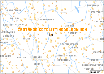
‘Izbat Sharikat al Ittiḩād al Qadīmah (Kafr ash Shaykh, Egypt)‘Izbat Sharikat al Ittiḩād al Qadīmah is a town in the Kafr ash Shaykh region of Egypt. An overview map of the region around ‘Izbat Sharikat al Ittiḩād al Qadīmah is displayed below.
regional and 3d topo map of ‘Izbat Sharikat al Ittiḩād al Qadīmah, Egypt ::
‘Izbat Sharikat al Ittiḩād al Qadīmah airports ::
The nearest airport is ALY - Alexandria Intl, located 99.8 km west of ‘Izbat Sharikat al Ittiḩād al Qadīmah.
Other airports nearby include PSD - Port Said (119.0 km east), CAI - Cairo Intl (124.0 km south), Nearby towns ::
‘Izbat Ḩusayn (1.1km south) //
‘Izbat Sharikat al Ittiḩād al Jadīdah (1.3km north) //
‘Izbat Ibrāhīm Māzin (1.8km south) //
‘Izbat ‘Abd al Maqşūd (1.8km north west) //
‘Izbat Muḩammad Sallām (1.8km south east) //
As Sarāyā (1.8km east) //
Al Makanah (2.0km north east) //
‘Izbat al Ḩūt (1.9km south west) //
Duqmayrah (2.1km east) //
‘Izbat Muḩammad Zahrān (2.8km north) //
Al ‘Awn (2.9km south east) //
Kafr al Murābi‘īn (3.0km south west) //
Al Murāb‘īn (3.2km south) //
Al Murābi‘īn (3.2km south) //
‘Izbat aţ Ţayyārah (3.3km north west) //
‘Izbat Abū Nijm (3.1km north east) //
Ash Shīlān (3.5km south) //
Al Khuḑayrī (3.7km south) //
‘Izbat Khalīfah Abū Ḩasan (3.6km north west) //
Nuşrah (4.3km south) //
‘Izbat Daqalt (4.0km south west) //
‘Izbat Khayr Allāh (4.0km north west) //
‘Izbat Abū Minays (4.2km north east) //
Idrījah (4.2km west) //
Al Ḩalāfī al Kabīr (4.5km north east) //
‘Izbat ad Disūqī ‘Azab (4.4km south west) //
Al Khādimīyah (4.4km east) //
‘Izbat Ḩabīb (5.1km south) //
Ash Shawkah (4.9km north east) //
[all distances 'as the bird flies' and approximate] 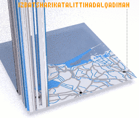 Places with similar names to ‘Izbat Sharikat al Ittiḩād al Qadīmah, Egypt ::
Disclaimer :: Information on this page comes without warranty of any kind |
||
|
Where is ‘Izbat Sharikat al Ittiḩād al Qadīmah? Elevation and coordinates ::
Latitude (lat): 31°10'58"N Longitude (lon): 30°59'45"E
Elevation (approx.): 5m (map arrows pan, magnifying glasses zoom) |
||
|
Visiting ‘Izbat Sharikat al Ittiḩād al Qadīmah? Hotel/Accommodation ::
Book a hotel in ‘Izbat Sharikat al Ittiḩād al Qadīmah Travel Guide ::
Buy a travel guide for Egypt rental cars ::
car rental offers GPS waypoint ::
download a GPX waypoint (PoI) of ‘Izbat Sharikat al Ittiḩād al Qadīmah for your GPS receiver
|
||