|
search place name
|
||
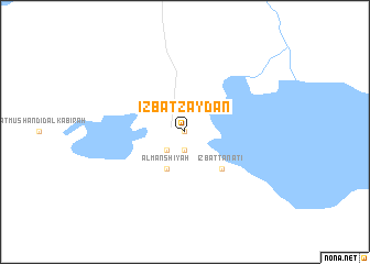
‘Izbat Zaydān (Maţrūḩ, Egypt)‘Izbat Zaydān is a town in the Maţrūḩ region of Egypt. An overview map of the region around ‘Izbat Zaydān is displayed below.
regional and 3d topo map of ‘Izbat Zaydān, Egypt ::
Nearby towns ::
‘Izbat Mallūl (0.0km north) //
Aghūrmī (1.9km south) //
Sīwah (2.5km south west) //
Al Manshīyah (4.0km south west) //
‘Izbat Ţanāţī (4.9km south east) //
[all distances 'as the bird flies' and approximate]  Places with similar names to ‘Izbat Zaydān, Egypt ::
// ‘Izbat as Sa‘ādnah (EG)
// ‘Izbat as Sa‘ādnah (EG)
// ‘Izbat aş Şayyādīn (EG)
// ‘Izbat Sa‘dūn (EG)
// ‘Izbat Zaydān (EG)
// ‘Izbat Zaydān (EG)
Disclaimer :: Information on this page comes without warranty of any kind |
||
|
Where is ‘Izbat Zaydān? Elevation and coordinates ::
Latitude (lat): 29°13'0"N Longitude (lon): 25°32'0"E
Elevation (approx.): -9m (map arrows pan, magnifying glasses zoom) |
||
|
Visiting ‘Izbat Zaydān? Hotel/Accommodation ::
Book a hotel in ‘Izbat Zaydān Travel Guide ::
Buy a travel guide for Egypt rental cars ::
car rental offers GPS waypoint ::
download a GPX waypoint (PoI) of ‘Izbat Zaydān for your GPS receiver
|
||