|
search place name
|
||
Kafr Sa`d (Dumyāţ, Egypt)Kafr Sa`d is a town in the Dumyāţ region of Egypt. An overview map of the region around Kafr Sa`d is displayed below.
regional and 3d topo map of Kafr Sa`d, Egypt ::

Kafr Sa`d airports ::
The nearest airport is PSD - Port Said, located 56.3 km east of Kafr Sa`d.
Other airports nearby include CAI - Cairo Intl (135.3 km south), ALY - Alexandria Intl (162.9 km west), Nearby towns ::
Kafr Sa‘d al Balad (0.1km south west) //
An Nāşirīyah (2.2km north west) //
Kafr Shiḩātah (2.4km south west) //
Ḩayy al ‘Urūbah (3.4km north) //
‘Izbat Dār as Salām (3.0km west) //
Kafr al Manāzilah (3.1km east) //
‘Izbat Abū Ţaha (3.7km south west) //
‘Izbat Şiddīq Shiḩātah (3.9km north west) //
Al Fuʼādīyah (4.5km north) //
Kafr Mīt Abū Ghālib (4.5km south) //
Al Ḩusānīyah (4.6km north) //
Mît Abu Ghâlib (4.7km south east) //
Al Muhandisīn (4.9km north) //
As Sawālim (5.5km south) //
Kafr al ‘Arab (4.9km south east) //
Al Muḩammadīyah (5.2km north west) //
‘Izbat al Alfī (4.9km north west) //
Ad Dinjūh (5.7km north) //
Sharabâṣ (5.5km south east) //
Kafr ash Shinnāwī (5.3km south east) //
As Sa‘īdīyah al Qiblīyah (6.0km north) //
‘Izbat al Ismā‘īlīyah Raqm Arba‘ah (6.0km north east) //
‘Izbat Sharabāş (6.4km south east) //
‘Izbat Muḩammad al Misīrī (6.2km south west) //
‘Izbat Kāmil al ‘Ajūz (6.1km south west) //
‘Izbat al Ismā‘īlīyah Raqm Thalāthah (6.7km north east) //
Kafr Sulaymān al Baḩrī (6.1km north east) //
‘Izbat Abū Ḩammūdah (6.2km south west) //
‘Izbat al Bartūn (6.3km south west) //
[all distances 'as the bird flies' and approximate] 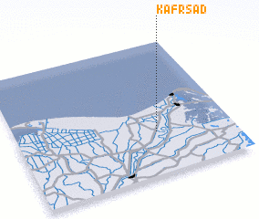 Places with similar names to Kafr Sa`d, Egypt ::
// Kafr as Sayyid (EG)
// Kafr az Zayyāt (EG)
// Cofăreşti (RO)
// Khvorosty (UA)
// Kafr Asad (JO)
// Kafr az Zayt (SY)
// Kafr Zaytā (SY)
// Kafr Zaytā (SY)
// Kafr aş Şa‘āydah (EG)
// Kafr aş Şa‘īdī (EG)
Disclaimer :: Information on this page comes without warranty of any kind |
||
|
Where is Kafr Sa`d? Elevation and coordinates ::
Latitude (lat): 31°19'27"N Longitude (lon): 31°39'5"E
Elevation (approx.): 8m (map arrows pan, magnifying glasses zoom) |
||
|
Visiting Kafr Sa`d? Hotel/Accommodation ::
Book a hotel in Kafr Sa`d Travel Guide ::
Buy a travel guide for Egypt rental cars ::
car rental offers GPS waypoint ::
download a GPX waypoint (PoI) of Kafr Sa`d for your GPS receiver
|
||