|
search place name
|
||
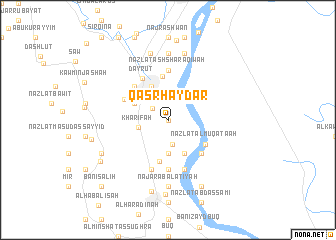
Qaşr Ḩaydar (Asyūţ, Egypt)Qaşr Ḩaydar is a town in the Asyūţ region of Egypt. An overview map of the region around Qaşr Ḩaydar is displayed below.
regional and 3d topo map of Qaşr Ḩaydar, Egypt ::
Qaşr Ḩaydar airports ::
The nearest airport is LXR - Luxor Intl, located 276.8 km south east of Qaşr Ḩaydar.
Nearby towns ::
Nazlat al Hawājil (0.0km north) //
Mazīnah (0.0km north) //
Nazlat Qalānish al Gharbīyah (0.0km north) //
Nazlat Bilāl (0.0km north) //
Kawm Būhā Baḩrī (2.0km north west) //
Al Mandarah Baḩrī (2.4km north) //
Masārah (2.8km south) //
Khārifah (3.0km west) //
Masārah (3.7km south) //
Nazlat Z̧āhir (3.8km north west) //
Al Qurashīyah (4.1km north west) //
Nazlat al Karāʼitah (4.1km south east) //
Fazārah (4.7km south) //
Nazlat Faraj Maḩmūd (4.5km north west) //
Shalash (4.9km north) //
Nazlat al Muqāţa‘ah (4.6km south east) //
Bānūb (5.0km north west) //
Dayr al Quşayr (5.0km south east) //
Biblāw wa Nazlat Badawī (4.9km north west) //
Dayrūţ (5.3km north west) //
Nazlat al Makhtūn (5.6km south) //
Nazlat ash Sharāqiwah (5.6km north) //
Banī Yaḩyá Baḩrī (5.6km north) //
Naj‘ ‘Arab Sālim Sulaymān (5.8km south) //
Nazlat ‘Alī ‘Abd al Jawwād (5.8km south) //
Nazlat ‘Abd Allāh (7.4km north) //
Naj‘ ‘Arab al ‘Aţīyah (7.4km south) //
Tanāghah (7.4km south) //
Ash Shaykh Dāʼūd (7.4km south) //
[all distances 'as the bird flies' and approximate]  Places with similar names to Qaşr Ḩaydar, Egypt :: Disclaimer :: Information on this page comes without warranty of any kind |
||
|
Where is Qaşr Ḩaydar? Elevation and coordinates ::
Latitude (lat): 27°31'0"N Longitude (lon): 30°50'0"E
Elevation (approx.): 47m (map arrows pan, magnifying glasses zoom) |
||
|
Visiting Qaşr Ḩaydar? Hotel/Accommodation ::
Book a hotel in Qaşr Ḩaydar Travel Guide ::
Buy a travel guide for Egypt rental cars ::
car rental offers GPS waypoint ::
download a GPX waypoint (PoI) of Qaşr Ḩaydar for your GPS receiver
|
||