|
search place name
|
||
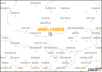
Debelyanovo (Bulgaria)Debelyanovo is a town in Bulgaria. An overview map of the region around Debelyanovo is displayed below.
regional and 3d topo map of Debelyanovo, Bulgaria ::
Debelyanovo airports ::
The nearest airport is PDV - Plovdiv, located 45.9 km north of Debelyanovo.
Other airports nearby include KVA - Kavala Megas Alexandros Intl (89.1 km south), AXD - Alexandroupolis Dimokritos (121.5 km south east), SOF - Sofia (173.3 km north west), GOZ - Gorna Orechovica Gorna Oryahovitsa (175.5 km north), Nearby towns ::
Vŭlchandol (2.3km north east) //
Bosilkovo (4.0km north) //
Krŭstatitsa (4.6km south west) //
Oryakhovets (5.6km south) //
Stŭrnitsa (4.2km west) //
Gabrina (5.7km south) //
Glogino (5.7km north) //
Banite (6.2km south east) //
Kupen (7.4km south) //
Kasapsko (7.5km south) //
Trave (5.8km east) //
Dve Topoli (6.9km north east) //
Belev Dol (6.9km south west) //
Malka Arda (6.9km south west) //
Dryanka (7.9km south) //
Vishnevo (7.8km south east) //
[all distances 'as the bird flies' and approximate] 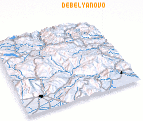 Places with similar names to Debelyanovo, Bulgaria :: Disclaimer :: Information on this page comes without warranty of any kind |
||
|
Where is Debelyanovo? Elevation and coordinates ::
Latitude (lat): 41°40'0"N Longitude (lon): 24°59'0"E
Elevation (approx.): 847m (map arrows pan, magnifying glasses zoom) |
||
|
Visiting Debelyanovo? Hotel/Accommodation ::
Book a hotel in Debelyanovo Travel Guide ::
Buy a travel guide for Bulgaria rental cars ::
car rental offers GPS waypoint ::
download a GPX waypoint (PoI) of Debelyanovo for your GPS receiver
|
||