|
search place name
|
||
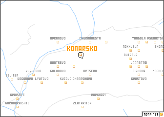
Konarsko (Bulgaria)Konarsko is a town in Bulgaria. An overview map of the region around Konarsko is displayed below.
regional and 3d topo map of Konarsko, Bulgaria ::
Konarsko airports ::
The nearest airport is SOF - Sofia, located 81.3 km north of Konarsko.
Other airports nearby include PDV - Plovdiv (94.2 km east), KVA - Kavala Megas Alexandros Intl (142.3 km south east), SKG - Thessaloniki Makedonia (175.9 km south), GOZ - Gorna Orechovica Gorna Oryahovitsa (207.9 km north east), Nearby towns ::
Vaklova (2.3km south west) //
Ortsevo (4.0km south) //
Cherna Mesta (4.0km north) //
Yakoruda (3.9km north west) //
Chereshovo (5.6km south) //
Buntsevo (4.5km south west) //
Smolevo (5.5km north east) //
Gŭlŭbovo (5.6km south west) //
Avramovo (5.5km north west) //
Kuzʼovo (6.2km south west) //
Palatnik (6.2km south west) //
[all distances 'as the bird flies' and approximate]  Places with similar names to Konarsko, Bulgaria ::
// Konarskie (PL)
// Konarskie (PL)
// Konarzówka (PL)
// Kon Rơsek (VN)
// Kiinnarissoq (GL)
// Kinreask (IE)
Disclaimer :: Information on this page comes without warranty of any kind |
||
|
Where is Konarsko? Elevation and coordinates ::
Latitude (lat): 42°0'0"N Longitude (lon): 23°43'0"E
Elevation (approx.): 1401m (map arrows pan, magnifying glasses zoom) |
||
|
Visiting Konarsko? Hotel/Accommodation ::
Book a hotel in Konarsko Travel Guide ::
Buy a travel guide for Bulgaria rental cars ::
car rental offers GPS waypoint ::
download a GPX waypoint (PoI) of Konarsko for your GPS receiver
|
||