|
search place name
|
||
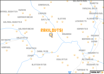
Rakilovtsi (Bulgaria)Rakilovtsi is a town in Bulgaria. An overview map of the region around Rakilovtsi is displayed below.
regional and 3d topo map of Rakilovtsi, Bulgaria ::
Rakilovtsi airports ::
The nearest airport is SOF - Sofia, located 51.0 km east of Rakilovtsi.
Other airports nearby include INI - Nis (117.6 km north west), SKP - Skopje (118.3 km south west), PRN - Pristina (146.3 km west), CRA - Craiova (214.8 km north east), Nearby towns ::
Kovachevtsi (0.1km north) //
Sirishtnik (1.9km north) //
Kosacha (3.3km north east) //
Lobosh (5.6km south) //
Radibosh (4.1km east) //
Svetlya (5.4km north) //
Kosturintsi (5.7km north) //
Slatino (6.2km north east) //
Zhablyano (6.8km south) //
Kalishte (7.1km south) //
Berende (7.4km north) //
Chepino (7.8km north) //
Peshtera (7.5km south west) //
Potsŭrnentsi (8.8km south east) //
Zemen (9.7km south west) //
Elovdol (10.0km north west) //
[all distances 'as the bird flies' and approximate]  Places with similar names to Rakilovtsi, Bulgaria ::
// Rakalafotsy (MG)
// Raklovtse (BY)
Disclaimer :: Information on this page comes without warranty of any kind |
||
|
Where is Rakilovtsi? Elevation and coordinates ::
Latitude (lat): 42°33'0"N Longitude (lon): 22°49'0"E
Elevation (approx.): 671m (map arrows pan, magnifying glasses zoom) |
||
|
Visiting Rakilovtsi? Hotel/Accommodation ::
Book a hotel in Rakilovtsi Travel Guide ::
Buy a travel guide for Bulgaria rental cars ::
car rental offers GPS waypoint ::
download a GPX waypoint (PoI) of Rakilovtsi for your GPS receiver
|
||