|
search place name
|
||
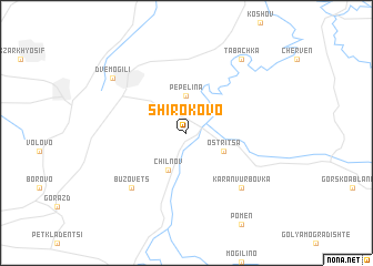
Shirokovo (Bulgaria)Shirokovo is a town in Bulgaria. An overview map of the region around Shirokovo is displayed below.
regional and 3d topo map of Shirokovo, Bulgaria ::
Shirokovo airports ::
The nearest airport is GOZ - Gorna Orechovica Gorna Oryahovitsa, located 47.8 km south of Shirokovo.
Other airports nearby include BBU - Bucharest Aurel Vlaicu (106.8 km north), OTP - Bucharest Henri Coanda (114.4 km north), VAR - Varna (157.3 km east), BOJ - Bourgas Burgas (168.7 km south east), Nearby towns ::
Pepelina (3.7km north) //
Chilnov (3.9km south) //
Ostritsa (3.3km south east) //
Karan Vŭrbovka (6.9km south east) //
Bŭzovets (6.9km south west) //
Dve Mogili (7.7km north west) //
Tabachka (8.4km north east) //
[all distances 'as the bird flies' and approximate] 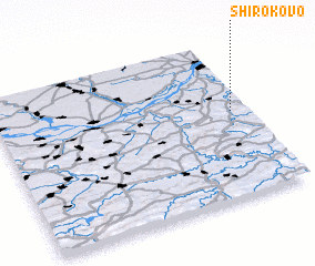 Places with similar names to Shirokovo, Bulgaria ::
Disclaimer :: Information on this page comes without warranty of any kind |
||
|
Where is Shirokovo? Elevation and coordinates ::
Latitude (lat): 43°33'0"N Longitude (lon): 25°56'0"E
Elevation (approx.): 206m (map arrows pan, magnifying glasses zoom) |
||
|
Visiting Shirokovo? Hotel/Accommodation ::
Book a hotel in Shirokovo Travel Guide ::
Buy a travel guide for Bulgaria rental cars ::
car rental offers GPS waypoint ::
download a GPX waypoint (PoI) of Shirokovo for your GPS receiver
|
||