|
search place name
|
||
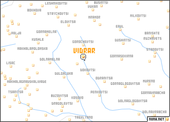
Vidrar (Bulgaria)Vidrar is a town in Bulgaria. An overview map of the region around Vidrar is displayed below.
regional and 3d topo map of Vidrar, Bulgaria ::
Vidrar airports ::
The nearest airport is SOF - Sofia, located 66.6 km east of Vidrar.
Other airports nearby include INI - Nis (95.3 km north west), SKP - Skopje (112.7 km south west), PRN - Pristina (128.4 km west), CRA - Craiova (210.5 km north east), Nearby towns ::
Leva Reka (1.4km south west) //
Dokʼovtsi (2.8km south) //
Gorochevtsi (3.5km north) //
Dŭlga Luka (4.9km south west) //
Odranitsa (5.5km south east) //
Dolna Melna (5.6km west) //
Gorna Sekirna (6.0km east) //
Penkʼovtsi (8.0km south) //
Kozhintsi (8.3km north) //
Elovitsa (8.3km north) //
Kosovo (8.9km south) //
Mramor (9.0km north) //
Dushintsi (7.3km north east) //
Bŭzovitsa (9.3km south west) //
Gorna Melna (8.4km north west) //
Erul (8.9km north east) //
[all distances 'as the bird flies' and approximate]  Places with similar names to Vidrar, Bulgaria ::
// Vitoreira (PT)
// Vitoreira (PT)
// Ghitrārī (IN)
// Ghatto Rora (PK)
// Voudouraré (ML)
// Vedrare (BG)
// Veitrier (FR)
Disclaimer :: Information on this page comes without warranty of any kind |
||
|
Where is Vidrar? Elevation and coordinates ::
Latitude (lat): 42°40'27"N Longitude (lon): 22°35'40"E
Elevation (approx.): 940m (map arrows pan, magnifying glasses zoom) |
||
|
Visiting Vidrar? Hotel/Accommodation ::
Book a hotel in Vidrar Travel Guide ::
Buy a travel guide for Bulgaria rental cars ::
car rental offers GPS waypoint ::
download a GPX waypoint (PoI) of Vidrar for your GPS receiver
|
||