|
search place name
|
||
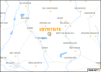
Voynitsite (Bulgaria)Voynitsite is a town in Bulgaria. An overview map of the region around Voynitsite is displayed below.
regional and 3d topo map of Voynitsite, Bulgaria ::
Voynitsite airports ::
The nearest airport is PDV - Plovdiv, located 36.7 km south west of Voynitsite.
Other airports nearby include GOZ - Gorna Orechovica Gorna Oryahovitsa (104.6 km north east), SOF - Sofia (151.2 km west), KVA - Kavala Megas Alexandros Intl (160.6 km south), AXD - Alexandroupolis Dimokritos (173.4 km south east), Nearby towns ::
Pravoslav (4.0km north) //
Tyurkmen (3.3km south west) //
Bratya Daskalovi (4.1km east) //
Granit (5.7km south) //
Malŭk Dol (5.5km north east) //
Veren (6.2km north east) //
Choba (5.8km west) //
Markovo (6.9km north east) //
Gorno Belevo (6.6km south east) //
Golyam Dol (6.6km north east) //
[all distances 'as the bird flies' and approximate] 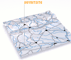 Places with similar names to Voynitsite, Bulgaria ::
// Voynitsite (BG)
// Finţeşti (RO)
// Ghiniţeşti (RO)
// Vineţeşti (RO)
// Fuentesoto (ES)
// Fundi Sadi (CD)
// Fonds Cede (HT)
// Vena di Sotto (IT)
// Ghindeşti (MD)
Disclaimer :: Information on this page comes without warranty of any kind |
||
|
Where is Voynitsite? Elevation and coordinates ::
Latitude (lat): 42°18'0"N Longitude (lon): 25°10'0"E
Elevation (approx.): 204m (map arrows pan, magnifying glasses zoom) |
||
|
Visiting Voynitsite? Hotel/Accommodation ::
Book a hotel in Voynitsite Travel Guide ::
Buy a travel guide for Bulgaria rental cars ::
car rental offers GPS waypoint ::
download a GPX waypoint (PoI) of Voynitsite for your GPS receiver
|
||