|
search place name
|
||
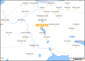
Briģene (Daugavpils Rajons, Latvia)Briģene is a town in the Daugavpils Rajons region of Latvia. An overview map of the region around Briģene is displayed below.
regional and 3d topo map of Briģene, Latvia ::
Briģene airports ::
The nearest airport is MHP - Minsk 1, located 219.6 km south of Briģene.
Other airports nearby include MSQ - Minsk 2 (229.1 km south east), Nearby towns ::
Demene (1.9km south) //
Spivakiški (2.1km north east) //
Dervaniški (3.7km north) //
Taržeķi (3.9km south) //
Renkavičeuka (5.6km north) //
Jānuciems (3.6km north east) //
Loskutovka (4.6km south west) //
Černija (7.5km north) //
Zemgale (5.6km south west) //
Kimbartiškė (7.7km south) //
Valodina (8.0km north east) //
Dankeri (6.9km north east) //
Birkeneļi (8.5km north west) //
Laskutauka (8.5km north east) //
[all distances 'as the bird flies' and approximate] 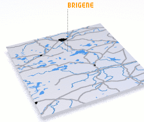 Places with similar names to Briģene, Latvia ::
// Bergen (AT)
// Bergen (AT)
// Bergin (AT)
// Brögen (AT)
// Burro John (US)
// Bargen (DE)
// Bargen (DE)
// Bargen (DE)
// Bargen (DE)
// Bauerrögen (DE)
Disclaimer :: Information on this page comes without warranty of any kind |
||
|
Where is Briģene? Elevation and coordinates ::
Latitude (lat): 55°45'0"N Longitude (lon): 26°32'0"E
Elevation (approx.): 154m (map arrows pan, magnifying glasses zoom) |
||
|
Visiting Briģene? Hotel/Accommodation ::
Book a hotel in Briģene Travel Guide ::
Buy a travel guide for Latvia rental cars ::
car rental offers GPS waypoint ::
download a GPX waypoint (PoI) of Briģene for your GPS receiver
|
||