|
search place name
|
||
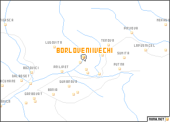
Borlovenii Vechi (Caraş-Severin, Romania)Borlovenii Vechi is a town in the Caraş-Severin region of Romania. An overview map of the region around Borlovenii Vechi is displayed below.
regional and 3d topo map of Borlovenii Vechi, Romania ::
Borlovenii Vechi airports ::
The nearest airport is CSB - Caransebes, located 52.3 km north of Borlovenii Vechi.
Other airports nearby include TSR - Timisoara Traian Vuia (112.0 km north west), BEG - Beograd (143.0 km west), ARW - Arad (150.4 km north west), CRA - Craiova (158.3 km south east), Nearby towns ::
Pătaş (0.8km west) //
Dâlmele Prigorului (1.8km south) //
Prigor (2.6km south) //
Borlovenii Noi (3.0km north east) //
Fata Seocului (3.6km south east) //
Prilipeţ (4.2km south west) //
Terova (5.1km north east) //
Dumbrava (6.0km south west) //
Eftimie Murgu (6.9km south) //
Ludovita (5.7km north west) //
Vârtopul Mare (7.4km south) //
Putna (5.6km east) //
Şumiţa (6.1km east) //
Bănia (8.8km south west) //
[all distances 'as the bird flies' and approximate] 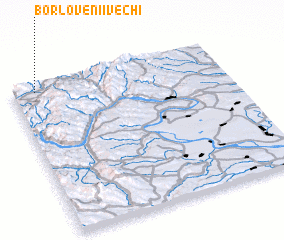 Places with similar names to Borlovenii Vechi, Romania :: Disclaimer :: Information on this page comes without warranty of any kind |
||
|
Where is Borlovenii Vechi? Elevation and coordinates ::
Latitude (lat): 44°57'40"N Longitude (lon): 22°6'29"E
Elevation (approx.): 370m (map arrows pan, magnifying glasses zoom) |
||
|
Visiting Borlovenii Vechi? Hotel/Accommodation ::
Book a hotel in Borlovenii Vechi Travel Guide ::
Buy a travel guide for Romania rental cars ::
car rental offers GPS waypoint ::
download a GPX waypoint (PoI) of Borlovenii Vechi for your GPS receiver
|
||