|
search place name
|
||
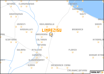
Limpezişu (Covurlui, Romania)Limpezişu is a town in the Covurlui region of Romania. An overview map of the region around Limpezişu is displayed below.
regional and 3d topo map of Limpezişu, Romania ::
Limpezişu airports ::
The nearest airport is OTP - Bucharest Henri Coanda, located 63.3 km south west of Limpezişu.
Other airports nearby include BBU - Bucharest Aurel Vlaicu (68.6 km south west), CND - Constanta Mihail Kogalniceanu (156.2 km south east), BCM - Bacau (175.5 km north), VAR - Varna (211.1 km south east), Nearby towns ::
Bugheni (2.3km north west) //
Cîmpeni (2.3km north west) //
Miluiţi (2.3km north west) //
Mărgineanu (2.6km west) //
Bughenii-Miluiţi (3.9km north) //
Movila Banului (3.9km north) //
Cioranca (3.9km north) //
Colţăneni (3.2km south west) //
Sărata-Mărgineanca (4.5km south west) //
Mihăileşti (4.5km south west) //
Satu Nou (4.5km south west) //
Lunca (5.6km west) //
Căldăruşanca (7.5km south) //
Pitulicea (6.8km south west) //
Florica (7.6km south east) //
Coşurile (7.6km south east) //
Cufuritu (8.4km south west) //
[all distances 'as the bird flies' and approximate] 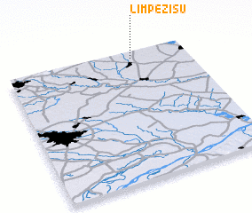 Places with similar names to Limpezişu, Romania ::
Disclaimer :: Information on this page comes without warranty of any kind |
||
|
Where is Limpezişu? Elevation and coordinates ::
Latitude (lat): 44°57'0"N Longitude (lon): 26°42'0"E
Elevation (approx.): 77m (map arrows pan, magnifying glasses zoom) |
||
|
Visiting Limpezişu? Hotel/Accommodation ::
Book a hotel in Limpezişu Travel Guide ::
Buy a travel guide for Romania rental cars ::
car rental offers GPS waypoint ::
download a GPX waypoint (PoI) of Limpezişu for your GPS receiver
|
||