|
search place name
|
||
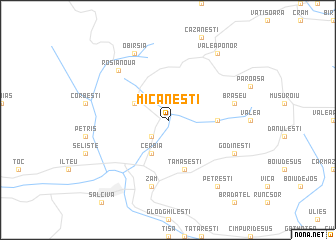
Micăneşti (Covurlui, Romania)Micăneşti is a town in the Covurlui region of Romania. An overview map of the region around Micăneşti is displayed below.
regional and 3d topo map of Micăneşti, Romania ::
Micăneşti airports ::
The nearest airport is CSB - Caransebes, located 73.8 km south of Micăneşti.
Other airports nearby include TSR - Timisoara Traian Vuia (92.1 km west), ARW - Arad (93.9 km west), OMR - Oradea (115.0 km north), CLJ - Cluj-napoca Cluj Napoca (123.1 km north east), Nearby towns ::
Pogăneşti (2.3km south west) //
Almăşel (3.2km north west) //
Cerbia (3.9km south) //
Almaş-Sălişte (3.9km east) //
Tămăşeşti (5.7km south) //
Brăşeu (5.5km east) //
Zam (7.5km south) //
Roşia Nouă (6.8km north west) //
Godineşti (6.3km south east) //
Obîrşia (7.8km north) //
Valea Bocşei (8.4km north east) //
Valea Ponor (8.4km north east) //
Cerboaia (8.4km north east) //
Petreşti (8.4km south east) //
[all distances 'as the bird flies' and approximate]  Places with similar names to Micăneşti, Romania ::
// Măicăneşti (RO)
// Megansett (US)
// Mackinaw City (US)
// Maggona East (LK)
// Maganisto (MZ)
// Myggnäset (SE)
// Maquinista (BO)
Disclaimer :: Information on this page comes without warranty of any kind |
||
|
Where is Micăneşti? Elevation and coordinates ::
Latitude (lat): 46°4'0"N Longitude (lon): 22°28'0"E
Elevation (approx.): 228m (map arrows pan, magnifying glasses zoom) |
||
|
Visiting Micăneşti? Hotel/Accommodation ::
Book a hotel in Micăneşti Travel Guide ::
Buy a travel guide for Romania rental cars ::
car rental offers GPS waypoint ::
download a GPX waypoint (PoI) of Micăneşti for your GPS receiver
|
||