|
search place name
|
||
Seliştat (Covurlui, Romania)Seliştat is a town in the Covurlui region of Romania. An overview map of the region around Seliştat is displayed below.
regional and 3d topo map of Seliştat, Romania ::

Seliştat airports ::
The nearest airport is SBZ - Sibiu, located 62.9 km west of Seliştat.
Other airports nearby include TGM - Tirgu Mures Vidrasau (63.5 km north west), CLJ - Cluj-napoca Cluj Napoca (126.3 km north west), OTP - Bucharest Henri Coanda (185.1 km south east), BBU - Bucharest Aurel Vlaicu (191.6 km south east), Nearby towns ::
Retişu (7.4km north) //
Rodbav (7.5km south) //
Bărcuţ (5.5km east) //
Movile (6.3km north west) //
Rora Cincului (8.4km south west) //
Cincu (8.4km south west) //
Şoarş (7.6km south east) //
Noiştat (8.4km north west) //
Netuş (9.0km north west) //
[all distances 'as the bird flies' and approximate] 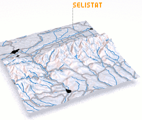 Places with similar names to Seliştat, Romania ::
// Selstad (NO)
// Selstad (NO)
// Slåstad (NO)
// Solstad (NO)
// Săliştiuţ (RO)
// Selestiuţa (RO)
// Sélestat (FR)
// Salles-dʼAude (FR)
// Søllested (DK)
// Søllested (DK)
Disclaimer :: Information on this page comes without warranty of any kind |
||
|
Where is Seliştat? Elevation and coordinates ::
Latitude (lat): 45°59'0"N Longitude (lon): 24°51'0"E
Elevation (approx.): 565m (map arrows pan, magnifying glasses zoom) |
||
|
Visiting Seliştat? Hotel/Accommodation ::
Book a hotel in Seliştat Travel Guide ::
Buy a travel guide for Romania rental cars ::
car rental offers GPS waypoint ::
download a GPX waypoint (PoI) of Seliştat for your GPS receiver
|
||