|
search place name
|
||
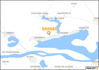
Smîrdan (Covurlui, Romania)Smîrdan is a town in the Covurlui region of Romania. An overview map of the region around Smîrdan is displayed below.
regional and 3d topo map of Smîrdan, Romania ::
Smîrdan airports ::
The nearest airport is BBU - Bucharest Aurel Vlaicu, located 85.7 km west of Smîrdan.
Other airports nearby include OTP - Bucharest Henri Coanda (88.8 km north west), CND - Constanta Mihail Kogalniceanu (112.0 km east), VAR - Varna (124.0 km south east), TCE - Tulcea Cataloi (158.9 km north east), Nearby towns ::
Bogata (1.3km east) //
Ciocăneşti (3.2km south west) //
Rasa (4.0km east) //
Vaidomir (4.0km east) //
Gălăţui (5.6km north) //
Alexandru Odobescu (5.7km north) //
Potcoava (6.2km north east) //
Cuneşti (5.3km east) //
Andolina (5.6km west) //
Nicolae Bălcescu (7.9km north) //
Independenţa (8.4km north east) //
[all distances 'as the bird flies' and approximate] 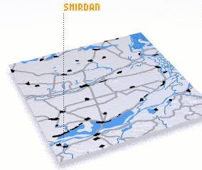 Places with similar names to Smîrdan, Romania ::
// Somerton (US)
// Summertown (US)
// Summertown (US)
// Symerton (US)
// Smerdyna (PL)
// Smrdan (BA)
// Smrdan (BA)
// Smŭrdan (BG)
// Ciomîrtan (RO)
// Smârdan (RO)
Disclaimer :: Information on this page comes without warranty of any kind |
||
|
Where is Smîrdan? Elevation and coordinates ::
Latitude (lat): 44°13'0"N Longitude (lon): 27°6'0"E
Elevation (approx.): 16m (map arrows pan, magnifying glasses zoom) |
||
|
Visiting Smîrdan? Hotel/Accommodation ::
Book a hotel in Smîrdan Travel Guide ::
Buy a travel guide for Romania rental cars ::
car rental offers GPS waypoint ::
download a GPX waypoint (PoI) of Smîrdan for your GPS receiver
|
||