|
search place name
|
||
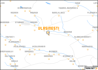
Vlăsineşti (Covurlui, Romania)Vlăsineşti is a town in the Covurlui region of Romania. An overview map of the region around Vlăsineşti is displayed below.
regional and 3d topo map of Vlăsineşti, Romania ::
Vlăsineşti airports ::
The nearest airport is SCV - Suceava Stefan Cel Mare, located 48.2 km south west of Vlăsineşti.
Other airports nearby include IAS - Iasi (100.6 km south east), BCM - Bacau (156.9 km south), Nearby towns ::
Miron Costin (0.0km north) //
Săveni (2.2km north west) //
Satu Nou (2.2km north west) //
Bozieni (2.2km north east) //
Sîrbi (3.1km north east) //
Petricani (4.2km north west) //
Vicolenii Mari (6.1km south west) //
Roşiori (5.3km north west) //
Chişcăreni (5.3km north west) //
Costeni (7.4km south) //
Bodeasa (5.0km east) //
Iacobeni (7.5km south) //
Vicoleni (6.7km south west) //
Buneni (7.8km south) //
Aurel Vlaicu (7.8km north) //
Epureni (8.3km south west) //
Ungureni-Isăcescu (7.5km south west) //
Vicolenii Mici (7.5km south west) //
Podriga (8.3km north west) //
Sapoveni (8.9km south west) //
[all distances 'as the bird flies' and approximate]  Places with similar names to Vlăsineşti, Romania ::
// Vîlsăneşti (RO)
// Velsen-Zuid (NL)
Disclaimer :: Information on this page comes without warranty of any kind |
||
|
Where is Vlăsineşti? Elevation and coordinates ::
Latitude (lat): 47°56'0"N Longitude (lon): 26°53'0"E
Elevation (approx.): 113m (map arrows pan, magnifying glasses zoom) |
||
|
Visiting Vlăsineşti? Hotel/Accommodation ::
Book a hotel in Vlăsineşti Travel Guide ::
Buy a travel guide for Romania rental cars ::
car rental offers GPS waypoint ::
download a GPX waypoint (PoI) of Vlăsineşti for your GPS receiver
|
||