|
search place name
|
||
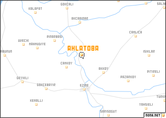
Ahlatoba (Çanakkale, Turkey)Ahlatoba is a town in the Çanakkale region of Turkey. An overview map of the region around Ahlatoba is displayed below.
regional and 3d topo map of Ahlatoba, Turkey ::
Ahlatoba airports ::
The nearest airport is MJT - Mytilini Mitilini, located 91.2 km south of Ahlatoba.
Other airports nearby include LXS - Limnos (93.9 km west), AXD - Alexandroupolis Dimokritos (116.0 km north), BZI - Balikesir (139.2 km east), BDM - Bandirma (149.7 km east), Nearby towns ::
 Places with similar names to Ahlatoba, Turkey ::
// Aldabó (CU)
// Alitub (RU)
// Aldeia Baia (MZ)
// Aldaba (ES)
// Al ‘Adhbah (QA)
// Aldaba (ES)
// Aldeby (GB)
// Aultbea (GB)
// Aldāba (IN)
// Āl Dibah (SA)
Disclaimer :: Information on this page comes without warranty of any kind |
||
|
Where is Ahlatoba? Elevation and coordinates ::
Latitude (lat): 39°51'5"N Longitude (lon): 26°19'49"E
Elevation (approx.): 101m (map arrows pan, magnifying glasses zoom) |
||
|
Visiting Ahlatoba? Hotel/Accommodation ::
Book a hotel in Ahlatoba Travel Guide ::
Buy a travel guide for Turkey rental cars ::
car rental offers GPS waypoint ::
download a GPX waypoint (PoI) of Ahlatoba for your GPS receiver
|
||