|
search place name
|
||
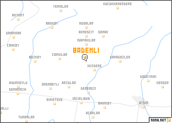
Bademli (Aydın, Turkey)Bademli is a town in the Aydın region of Turkey. An overview map of the region around Bademli is displayed below.
regional and 3d topo map of Bademli, Turkey ::
Bademli airports ::
The nearest airport is ADB - Izmir Adnan Menderes, located 64.4 km north west of Bademli.
Other airports nearby include SMI - Samos (77.2 km west), IGL - Izmir Cigli (90.3 km north west), LRS - Leros (117.0 km south west), KGS - Kos (138.7 km south west), Nearby towns ::
İkizdere (2.4km south east) //
İsafakılar (3.7km north) //
Akmescit (5.6km north) //
Çarıklar (4.6km west) //
Arzular (6.3km south west) //
Somak (6.3km north east) //
Dereağzı (6.7km south) //
Karagözler (5.8km east) //
Musalar (7.4km north) //
Ömerbeyli (8.5km south west) //
Başköy (9.4km north west) //
[all distances 'as the bird flies' and approximate] 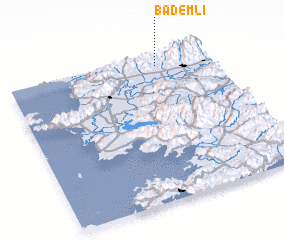 Places with similar names to Bademli, Turkey ::
// Buadi-Amaloy (PH)
// Buddemühle (DE)
// Bademli (TR)
// Bademli (TR)
// Bademli (TR)
// Bademli (TR)
// Bademli (TR)
// Bademli (TR)
// Bademli (TR)
// Bademli (TR)
Disclaimer :: Information on this page comes without warranty of any kind |
||
|
Where is Bademli? Elevation and coordinates ::
Latitude (lat): 37°56'0"N Longitude (lon): 27°44'0"E
Elevation (approx.): 306m (map arrows pan, magnifying glasses zoom) |
||
|
Visiting Bademli? Hotel/Accommodation ::
Book a hotel in Bademli Travel Guide ::
Buy a travel guide for Turkey rental cars ::
car rental offers GPS waypoint ::
download a GPX waypoint (PoI) of Bademli for your GPS receiver
|
||