|
search place name
|
||
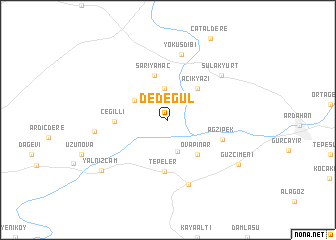
Dedegül (Ardahan, Turkey)Dedegül is a town in the Ardahan region of Turkey. An overview map of the region around Dedegül is displayed below.
regional and 3d topo map of Dedegül, Turkey ::
Dedegül airports ::
The nearest airport is ERZ - Erzurum, located 175.2 km south west of Dedegül.
Nearby towns ::
Kazlıköy (3.6km north) //
Akkaya (3.6km south) //
Çetinsu (3.6km north west) //
Açıkyazı (4.4km north east) //
Ovapınar (4.6km south east) //
Sarıyamaç (5.1km north) //
Tepeler (5.7km south) //
Çeğilli (4.5km west) //
Ağzıpek (5.1km south east) //
Değirmenli (7.3km north) //
Yokuşdibi (7.3km north) //
Yukarımahalle (7.4km south) //
Sulakyurt (6.7km north east) //
Çimenkaya (6.3km west) //
Güzçimeni (7.7km south east) //
Yalnızçam (8.0km south west) //
[all distances 'as the bird flies' and approximate]  Places with similar names to Dedegül, Turkey ::
// Tata-Gol (RU)
// Dadağlı (TR)
// Dadağlı (TR)
// Dedeoğlu (TR)
// Dudaklı (TR)
// Dodo-Gol (RU)
// Kāl-e Dadeh (IR)
// Tatakouélé (BF)
// Tatoukila (CG)
// Tādikal (IN)
Disclaimer :: Information on this page comes without warranty of any kind |
||
|
Where is Dedegül? Elevation and coordinates ::
Latitude (lat): 41°7'5"N Longitude (lon): 42°34'12"E
Elevation (approx.): 1807m (map arrows pan, magnifying glasses zoom) |
||
|
Visiting Dedegül? Hotel/Accommodation ::
Book a hotel in Dedegül Travel Guide ::
Buy a travel guide for Turkey rental cars ::
car rental offers GPS waypoint ::
download a GPX waypoint (PoI) of Dedegül for your GPS receiver
|
||