|
search place name
|
||
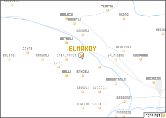
Elmaköy (Erzincan, Turkey)Elmaköy is a town in the Erzincan region of Turkey. An overview map of the region around Elmaköy is displayed below.
regional and 3d topo map of Elmaköy, Turkey ::
Elmaköy airports ::
The nearest airport is ERC - Erzincan, located 18.2 km south east of Elmaköy.
Other airports nearby include EZS - Elazig (132.6 km south), TZX - Trabzon (137.9 km north), ERZ - Erzurum (156.7 km east), MLX - Malatya Erhac (186.6 km south west), Nearby towns ::
Bahçeli (3.7km south) //
Çatalarmut (2.8km west) //
Hürrenpalangası (3.4km south east) //
Ballı (4.7km south west) //
Heybeli (4.7km north west) //
Davarlı (5.6km north) //
Ekinci (4.7km south west) //
Yalnızbağ (5.7km east) //
Cevizli (7.4km south) //
Aydoğdu (7.9km south) //
Ahmetli (8.2km north) //
Gümüştarla (8.0km south east) //
[all distances 'as the bird flies' and approximate] 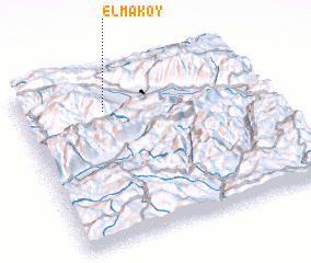 Places with similar names to Elmaköy, Turkey ::
Disclaimer :: Information on this page comes without warranty of any kind |
||
|
Where is Elmaköy? Elevation and coordinates ::
Latitude (lat): 39°48'0"N Longitude (lon): 39°21'0"E
Elevation (approx.): 1340m (map arrows pan, magnifying glasses zoom) |
||
|
Visiting Elmaköy? Hotel/Accommodation ::
Book a hotel in Elmaköy Travel Guide ::
Buy a travel guide for Turkey rental cars ::
car rental offers GPS waypoint ::
download a GPX waypoint (PoI) of Elmaköy for your GPS receiver
|
||