|
search place name
|
||
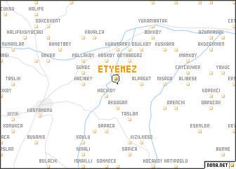
Etyemez (Kastamonu, Turkey)Etyemez is a town in the Kastamonu region of Turkey. An overview map of the region around Etyemez is displayed below.
regional and 3d topo map of Etyemez, Turkey ::
Etyemez airports ::
The nearest airport is MZH - Merzifon, located 152.3 km south east of Etyemez.
Other airports nearby include ESB - Ankara Esenboga (161.6 km south west), ANK - Ankara Etimesgut (191.7 km south west), Nearby towns ::
Ömerli (1.9km north) //
Hacıköy (2.3km south west) //
Alpagut (2.8km east) //
Akdoğan (3.7km south) //
Hasköy (4.0km north) //
Ortaboğaz (4.0km north) //
Bozoğlak (4.0km north) //
Hacıbey (4.2km west) //
Kurusaray (5.6km north) //
Gümeç (4.6km north west) //
Taşlan (5.7km south) //
Hatipköy (5.7km north) //
Mollaköy (5.6km north west) //
Oğulköy (6.2km north east) //
Nisağa (5.6km east) //
Sapaca (7.5km south) //
Kavalca (7.9km north) //
Çorumlu (7.9km south) //
Deliler (6.7km south east) //
İnceboğaz (8.5km north west) //
Bükköy (8.5km north east) //
Kuşkara (7.9km north east) //
[all distances 'as the bird flies' and approximate] 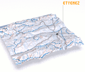
Disclaimer :: Information on this page comes without warranty of any kind |
||
|
Where is Etyemez? Elevation and coordinates ::
Latitude (lat): 41°25'0"N Longitude (lon): 33°53'0"E
Elevation (approx.): 826m (map arrows pan, magnifying glasses zoom) |
||
|
Visiting Etyemez? Hotel/Accommodation ::
Book a hotel in Etyemez Travel Guide ::
Buy a travel guide for Turkey rental cars ::
car rental offers GPS waypoint ::
download a GPX waypoint (PoI) of Etyemez for your GPS receiver
|
||