|
search place name
|
||
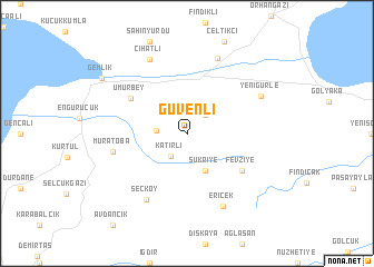
Güvenli (Bursa, Turkey)Güvenli is a town in the Bursa region of Turkey. An overview map of the region around Güvenli is displayed below.
regional and 3d topo map of Güvenli, Turkey ::
Güvenli airports ::
The nearest airport is IST - Istanbul Ataturk, located 74.8 km north west of Güvenli.
Other airports nearby include BDM - Bandirma (106.9 km west), ESK - Eskisehir (132.9 km south east), BZI - Balikesir (140.2 km south west), AFY - Afyon (218.3 km south east), Nearby towns ::
Karsak (2.3km north east) //
Katırlı (2.6km south west) //
Adliye (2.4km west) //
Hamidiye (4.0km south) //
Şükriye (4.0km south) //
Umurbey (5.5km north west) //
Fevziye (5.6km south east) //
Muratoba (5.9km west) //
Seçköy (7.3km south west) //
Gedelek (7.9km north) //
Ericek (7.8km south) //
Cihatlı (7.9km north) //
Gürle (6.8km north east) //
Yenigürle (6.8km north east) //
Gemlik (8.5km north west) //
[all distances 'as the bird flies' and approximate] 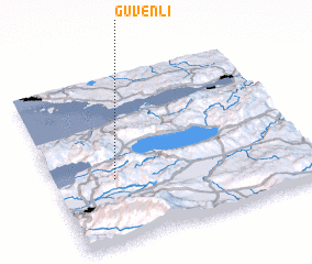 Places with similar names to Güvenli, Turkey ::
Disclaimer :: Information on this page comes without warranty of any kind |
||
|
Where is Güvenli? Elevation and coordinates ::
Latitude (lat): 40°23'0"N Longitude (lon): 29°14'0"E
Elevation (approx.): 596m (map arrows pan, magnifying glasses zoom) |
||
|
Visiting Güvenli? Hotel/Accommodation ::
Book a hotel in Güvenli Travel Guide ::
Buy a travel guide for Turkey rental cars ::
car rental offers GPS waypoint ::
download a GPX waypoint (PoI) of Güvenli for your GPS receiver
|
||