|
search place name
|
||
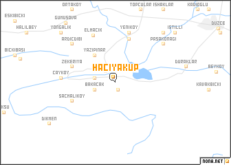
Hacıyakup (Bolu, Turkey)Hacıyakup is a town in the Bolu region of Turkey. An overview map of the region around Hacıyakup is displayed below.
regional and 3d topo map of Hacıyakup, Turkey ::
Hacıyakup airports ::
The nearest airport is ESK - Eskisehir, located 114.4 km south of Hacıyakup.
Other airports nearby include ANK - Ankara Etimesgut (168.4 km south east), ESB - Ankara Esenboga (182.2 km east), Nearby towns ::
Yunusefendi (1.2km south) //
Gölyaka (2.1km north west) //
Açma (2.6km west) //
Bakacak (2.8km south west) //
Yazıpınar (5.0km north west) //
Köprübaşı (7.2km north) //
Zekeriya (5.9km north west) //
Saçmalıköy (6.1km south west) //
Yeniköy (8.3km north) //
Elmacık (8.1km north) //
Çayköy (6.7km west) //
Ardıçdibi (8.2km north west) //
Paşakonağı (8.6km north east) //
Bahçeköy (10.0km north east) //
Yongalık (10.5km north west) //
[all distances 'as the bird flies' and approximate] 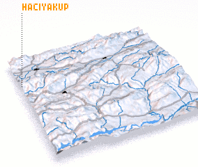
Disclaimer :: Information on this page comes without warranty of any kind |
||
|
Where is Hacıyakup? Elevation and coordinates ::
Latitude (lat): 40°45'38"N Longitude (lon): 31°0'47"E
Elevation (approx.): 147m (map arrows pan, magnifying glasses zoom) |
||
|
Visiting Hacıyakup? Hotel/Accommodation ::
Book a hotel in Hacıyakup Travel Guide ::
Buy a travel guide for Turkey rental cars ::
car rental offers GPS waypoint ::
download a GPX waypoint (PoI) of Hacıyakup for your GPS receiver
|
||