|
search place name
|
||
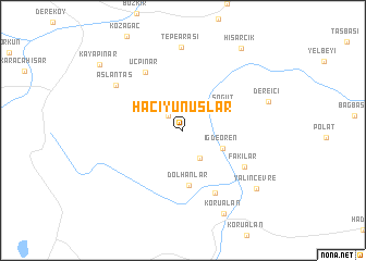
Hacıyunuslar (Turkey)Hacıyunuslar is a town in Turkey. An overview map of the region around Hacıyunuslar is displayed below.
regional and 3d topo map of Hacıyunuslar, Turkey ::
Hacıyunuslar airports ::
The nearest airport is KYA - Konya, located 102.6 km north of Hacıyunuslar.
Other airports nearby include AYT - Antalya (134.2 km west), AFY - Afyon (235.5 km north west), Nearby towns ::
Soğucak (1.9km north west) //
Bapuççular (3.2km south east) //
İğdeören (3.7km south east) //
Söğüt (4.1km north east) //
Dolhanlar (5.6km south) //
Üçpınar (6.7km north west) //
Dedemli (7.0km south) //
Fakılar (6.3km south east) //
Aslantaş (7.2km north west) //
Tepearası (8.6km north) //
Dereiçi (7.5km north east) //
Korualan (9.2km south) //
Yalınçevre (8.5km south east) //
Hisarcık (9.7km north east) //
Kayapınar (9.6km north west) //
[all distances 'as the bird flies' and approximate] 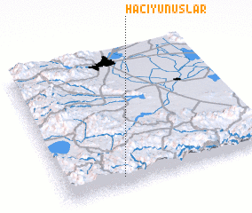 Places with similar names to Hacıyunuslar, Turkey :: Disclaimer :: Information on this page comes without warranty of any kind |
||
|
Where is Hacıyunuslar? Elevation and coordinates ::
Latitude (lat): 37°4'48"N Longitude (lon): 32°17'28"E
Elevation (approx.): 1716m (map arrows pan, magnifying glasses zoom) |
||
|
Visiting Hacıyunuslar? Hotel/Accommodation ::
Book a hotel in Hacıyunuslar Travel Guide ::
Buy a travel guide for Turkey rental cars ::
car rental offers GPS waypoint ::
download a GPX waypoint (PoI) of Hacıyunuslar for your GPS receiver
|
||