|
search place name
|
||
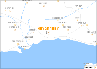
Haydarbey (Van, Turkey)Haydarbey is a town in the Van region of Turkey. An overview map of the region around Haydarbey is displayed below.
regional and 3d topo map of Haydarbey, Turkey ::
Haydarbey airports ::
The nearest airport is VAN - Van, located 61.3 km south of Haydarbey.
Nearby towns ::
 Places with similar names to Haydarbey, Turkey ::
// Hato Arriba (CU)
// Haydaroba (TR)
// Hueto Arriba (ES)
// Hato Arriba (VE)
// Hato Arriba (VE)
// Hato Arriba (US)
// Hải Triều (1) (VN)
// Hato Arriba (DO)
// Haut-Orbé (FR)
Disclaimer :: Information on this page comes without warranty of any kind |
||
|
Where is Haydarbey? Elevation and coordinates ::
Latitude (lat): 39°1'0"N Longitude (lon): 43°25'0"E
Elevation (approx.): 1787m (map arrows pan, magnifying glasses zoom) |
||
|
Visiting Haydarbey? Hotel/Accommodation ::
Book a hotel in Haydarbey Travel Guide ::
Buy a travel guide for Turkey rental cars ::
car rental offers GPS waypoint ::
download a GPX waypoint (PoI) of Haydarbey for your GPS receiver
|
||