|
search place name
|
||
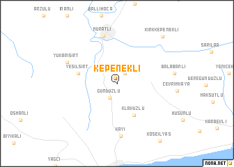
Kepenekli (Tekirdağ, Turkey)Kepenekli is a town in the Tekirdağ region of Turkey. An overview map of the region around Kepenekli is displayed below.
regional and 3d topo map of Kepenekli, Turkey ::
Kepenekli airports ::
The nearest airport is BDM - Bandirma, located 95.2 km south east of Kepenekli.
Other airports nearby include IST - Istanbul Ataturk (109.6 km east), AXD - Alexandroupolis Dimokritos (134.6 km west), BOJ - Bourgas Burgas (163.0 km north), BZI - Balikesir (168.2 km south), Nearby towns ::
Müsellim (1.9km north east) //
Gündüzlü (2.4km south) //
Klavuzlu (5.4km south) //
Yeşilsırt (4.9km west) //
Muratlı (7.9km north) //
Kayı (8.5km south) //
Yukarısırt (7.0km north west) //
Kırkkepenekli (9.4km north east) //
[all distances 'as the bird flies' and approximate]  Places with similar names to Kepenekli, Turkey ::
// Kapongolo (CD)
// Kaïpongal (SN)
// Kipounigali (SN)
// Kapangala (ZM)
// Kapangula (ZM)
// Kapangula (ZM)
// Kipp'un-gol (KP)
// Kip'ŭn-gol (KP)
// Kip'un-gol (KR)
// Capangala (MZ)
Disclaimer :: Information on this page comes without warranty of any kind |
||
|
Where is Kepenekli? Elevation and coordinates ::
Latitude (lat): 41°6'8"N Longitude (lon): 27°31'20"E
Elevation (approx.): 141m (map arrows pan, magnifying glasses zoom) |
||
|
Visiting Kepenekli? Hotel/Accommodation ::
Book a hotel in Kepenekli Travel Guide ::
Buy a travel guide for Turkey rental cars ::
car rental offers GPS waypoint ::
download a GPX waypoint (PoI) of Kepenekli for your GPS receiver
|
||