|
search place name
|
||
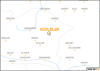
Kızıloluk (Sivas, Turkey)Kızıloluk is a town in the Sivas region of Turkey. An overview map of the region around Kızıloluk is displayed below.
regional and 3d topo map of Kızıloluk, Turkey ::
Kızıloluk airports ::
The nearest airport is ERC - Erzincan, located 114.3 km east of Kızıloluk.
Other airports nearby include VAS - Sivas (115.0 km west), MLX - Malatya Erhac (170.4 km south), TZX - Trabzon (174.5 km north east), EZS - Elazig (176.4 km south east), Nearby towns ::
Kılıçlar (4.7km south west) //
Mahmut (4.6km south west) //
Erence (5.7km north) //
Karacaören (6.0km west) //
Dağyurt (6.8km south east) //
[all distances 'as the bird flies' and approximate] 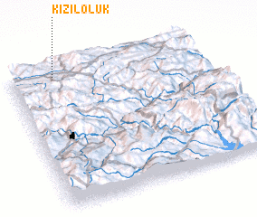 Places with similar names to Kızıloluk, Turkey ::
// Casa la Laca (IT)
// Güzeloluk (TR)
// Kızıloluk (TR)
// Kysyl-Yllyk (RU)
// Kusilulik (TP)
// Kuz Lālku (PK)
Disclaimer :: Information on this page comes without warranty of any kind |
||
|
Where is Kızıloluk? Elevation and coordinates ::
Latitude (lat): 39°58'0"N Longitude (lon): 38°14'0"E
Elevation (approx.): 2033m (map arrows pan, magnifying glasses zoom) |
||
|
Visiting Kızıloluk? Hotel/Accommodation ::
Book a hotel in Kızıloluk Travel Guide ::
Buy a travel guide for Turkey rental cars ::
car rental offers GPS waypoint ::
download a GPX waypoint (PoI) of Kızıloluk for your GPS receiver
|
||