|
search place name
|
||
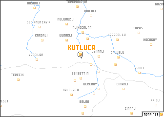
Kutluca (Kocaeli, Turkey)Kutluca is a town in the Kocaeli region of Turkey. An overview map of the region around Kutluca is displayed below.
regional and 3d topo map of Kutluca, Turkey ::
Kutluca airports ::
The nearest airport is IST - Istanbul Ataturk, located 78.9 km west of Kutluca.
Other airports nearby include ESK - Eskisehir (143.9 km south east), BDM - Bandirma (163.7 km south west), BZI - Balikesir (211.3 km south west), Nearby towns ::
Sevindikli (2.1km south east) //
Osmanlı (3.0km east) //
Şemsettin (4.5km south) //
Kırcalı (4.6km north) //
Karayakuplu (4.2km south east) //
Naipköy (5.3km south) //
Duraklı (4.9km north west) //
Alihocalar (6.0km north) //
Dereköy (7.1km south) //
Himmetli (5.9km east) //
Demirciler (7.5km south east) //
Çavuşlu (6.3km east) //
İgnedikli (8.3km south) //
Melemezli (8.3km north) //
Kalburcu (8.5km south) //
Karagöllü (7.5km north east) //
[all distances 'as the bird flies' and approximate]  Places with similar names to Kutluca, Turkey ::
// Catolog (PH)
// Gutalac (PH)
// Kotlik (US)
// Cadillac (US)
// Ca del Lago (IT)
// Ca di Lugo (IT)
// Kotłówka (PL)
// Kotłówka (PL)
// Kudelki (PL)
// Kőtelek (HU)
Disclaimer :: Information on this page comes without warranty of any kind |
||
|
Where is Kutluca? Elevation and coordinates ::
Latitude (lat): 40°54'45"N Longitude (lon): 29°44'54"E
Elevation (approx.): 242m (map arrows pan, magnifying glasses zoom) |
||
|
Visiting Kutluca? Hotel/Accommodation ::
Book a hotel in Kutluca Travel Guide ::
Buy a travel guide for Turkey rental cars ::
car rental offers GPS waypoint ::
download a GPX waypoint (PoI) of Kutluca for your GPS receiver
|
||