|
search place name
|
||
Mesutlar (Turkey)Mesutlar is a town in Turkey. An overview map of the region around Mesutlar is displayed below.
regional and 3d topo map of Mesutlar, Turkey ::

Mesutlar airports ::
The nearest airport is KYA - Konya, located 68.3 km north east of Mesutlar.
Other airports nearby include AYT - Antalya (130.5 km south west), AFY - Afyon (157.5 km north west), Nearby towns ::
Eğirler (3.1km north west) //
Çivril (5.1km south) //
Başgöze (5.2km north east) //
Karahisar (5.6km south) //
Gönen (5.9km north) //
Bayat (5.3km south west) //
Hüseyinler (5.9km south east) //
Bektemir (6.9km south west) //
Fasıllar (7.1km south east) //
Çiçekler (7.7km south) //
Göçü (7.5km north west) //
Gündoğdu (8.8km north west) //
[all distances 'as the bird flies' and approximate] 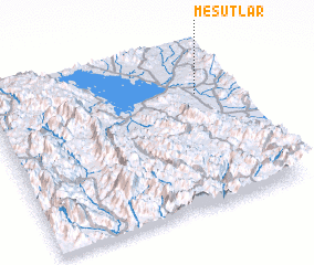 Places with similar names to Mesutlar, Turkey ::
// Mǝşǝdilǝr (AZ)
// Mǝşǝdilǝr (AZ)
// Mezitler (TR)
// Mostoller (US)
// Mesa del Aire (MX)
// Mazd Dahlar (IR)
// Mistolar (PY)
Disclaimer :: Information on this page comes without warranty of any kind |
||
|
Where is Mesutlar? Elevation and coordinates ::
Latitude (lat): 37°42'52"N Longitude (lon): 31°51'40"E
Elevation (approx.): 1335m (map arrows pan, magnifying glasses zoom) |
||
|
Visiting Mesutlar? Hotel/Accommodation ::
Book a hotel in Mesutlar Travel Guide ::
Buy a travel guide for Turkey rental cars ::
car rental offers GPS waypoint ::
download a GPX waypoint (PoI) of Mesutlar for your GPS receiver
|
||