|
search place name
|
||
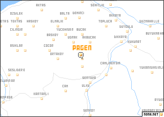
Pagen (Rize, Turkey)Pagen is a town in the Rize region of Turkey. An overview map of the region around Pagen is displayed below.
regional and 3d topo map of Pagen, Turkey ::
Pagen airports ::
The nearest airport is TZX - Trabzon, located 97.8 km west of Pagen.
Other airports nearby include ERZ - Erzurum (122.9 km south), ERC - Erzincan (191.7 km south west), Nearby towns ::
Akyamaç (0.0km north) //
Aslan (1.9km south) //
Akbucak (4.0km north) //
Uğrak (4.0km north) //
Ortaköy (4.2km west) //
Bucak (5.6km north) //
Şenyuva (5.7km south) //
Yolkıyı (5.6km south east) //
Yücehisar (6.2km north west) //
Çamlıhemşin (5.4km south east) //
Ülkü (7.4km south) //
Çoçor (5.9km west) //
Başköy (6.6km north west) //
Çam (7.9km south) //
Topluca (8.5km north east) //
Elmalık (8.5km north west) //
Akkaya (10.5km north east) //
[all distances 'as the bird flies' and approximate]  Places with similar names to Pagen, Turkey ::
Disclaimer :: Information on this page comes without warranty of any kind |
||
|
Where is Pagen? Elevation and coordinates ::
Latitude (lat): 41°3'0"N Longitude (lon): 40°57'0"E
Elevation (approx.): 754m (map arrows pan, magnifying glasses zoom) |
||
|
Visiting Pagen? Hotel/Accommodation ::
Book a hotel in Pagen Travel Guide ::
Buy a travel guide for Turkey rental cars ::
car rental offers GPS waypoint ::
download a GPX waypoint (PoI) of Pagen for your GPS receiver
|
||