|
search place name
|
||
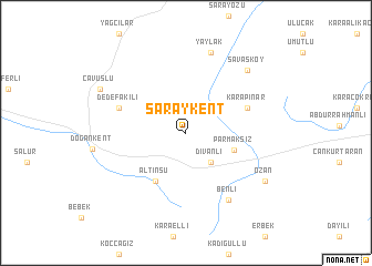
Saraykent (Yozgat, Turkey)Saraykent is a town in the Yozgat region of Turkey. An overview map of the region around Saraykent is displayed below.
regional and 3d topo map of Saraykent, Turkey ::
Saraykent airports ::
The nearest airport is ASR - Kayseri Erkilet, located 102.5 km south of Saraykent.
Other airports nearby include VAS - Sivas (120.1 km east), MZH - Merzifon (126.1 km north), Nearby towns ::
Divanlı (3.5km south east) //
Parmaksız (4.1km south east) //
Altınsu (5.4km south west) //
Karapınar (5.4km north east) //
Dedefakılı (5.8km north west) //
Benli (7.5km south east) //
Yaylak (8.3km north) //
Savaşköy (7.9km north east) //
Ozan (7.9km south east) //
Çavuşlu (8.0km north west) //
[all distances 'as the bird flies' and approximate]  Places with similar names to Saraykent, Turkey ::
// Şorkǝnd (AZ)
// Şurakǝnd (AZ)
// Şurakǝnd (AZ)
// Şurakǝnd (AZ)
// Cerro Cañito (PA)
// Sarıkent (TR)
// Sarai Kānda (BD)
// Serkāndi (BD)
// Soārkāndi (BD)
// Soria Gando (BJ)
Disclaimer :: Information on this page comes without warranty of any kind |
||
|
Where is Saraykent? Elevation and coordinates ::
Latitude (lat): 39°41'37"N Longitude (lon): 35°30'40"E
Elevation (approx.): 1118m (map arrows pan, magnifying glasses zoom) |
||
|
Visiting Saraykent? Hotel/Accommodation ::
Book a hotel in Saraykent Travel Guide ::
Buy a travel guide for Turkey rental cars ::
car rental offers GPS waypoint ::
download a GPX waypoint (PoI) of Saraykent for your GPS receiver
|
||