|
search place name
|
||
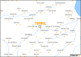
Tombul (Sinop, Turkey)Tombul is a town in the Sinop region of Turkey. An overview map of the region around Tombul is displayed below.
regional and 3d topo map of Tombul, Turkey ::
Tombul airports ::
The nearest airport is MZH - Merzifon, located 121.3 km south east of Tombul.
Other airports nearby include ESB - Ankara Esenboga (250.8 km south west), Nearby towns ::
Karapınar (2.3km south east) //
Dereköy (2.3km north east) //
Çoroğlu (2.8km east) //
Kızılcaelma (2.8km west) //
Soğucalı (3.3km north west) //
Altınyayla (4.0km south) //
Tepealtı (6.2km south east) //
Erfelek (6.2km north west) //
Sarıboğa (5.6km south west) //
Kaldırayak (5.6km north west) //
Göllü (7.4km south) //
Çakıldak (7.4km south) //
Alasökü (5.5km east) //
Veysel (7.4km north) //
Erikli (5.8km east) //
Hasandere (7.5km north) //
Değirmencili (7.5km north) //
Türkmen (7.9km south) //
Tangal (6.7km south east) //
Hamidiye (8.9km north) //
Kirençukuru (8.5km south east) //
Akçaçam (8.5km north east) //
Çayırköy (7.8km south west) //
İnesökü (9.2km north west) //
[all distances 'as the bird flies' and approximate] 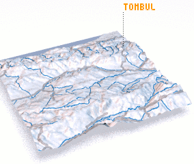 Places with similar names to Tombul, Turkey ::
Disclaimer :: Information on this page comes without warranty of any kind |
||
|
Where is Tombul? Elevation and coordinates ::
Latitude (lat): 41°50'0"N Longitude (lon): 34°57'0"E
Elevation (approx.): 341m (map arrows pan, magnifying glasses zoom) |
||
|
Visiting Tombul? Hotel/Accommodation ::
Book a hotel in Tombul Travel Guide ::
Buy a travel guide for Turkey rental cars ::
car rental offers GPS waypoint ::
download a GPX waypoint (PoI) of Tombul for your GPS receiver
|
||