|
search place name
|
||
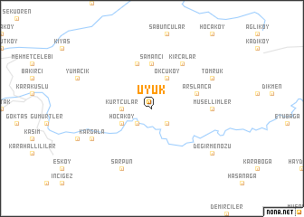
Üyük (Kastamonu, Turkey)Üyük is a town in the Kastamonu region of Turkey. An overview map of the region around Üyük is displayed below.
regional and 3d topo map of Üyük, Turkey ::
Üyük airports ::
The nearest airport is ESB - Ankara Esenboga, located 171.2 km south of Üyük.
Other airports nearby include ANK - Ankara Etimesgut (197.2 km south), Nearby towns ::
Sarayköy (2.3km south west) //
Kayaoğlu (2.3km south east) //
Kurtçular (2.8km west) //
Hocaköy (3.3km south west) //
Okçuköy (4.0km north) //
Samancı (5.6km north) //
Akçaçam (5.7km north) //
Arslanca (4.5km north east) //
Kırcalar (6.2km north east) //
Müsellimler (5.5km east) //
Kargala (6.7km south west) //
Sarpun (7.9km south) //
Tomruk (6.7km north east) //
Değirmenözü (7.9km south east) //
[all distances 'as the bird flies' and approximate] 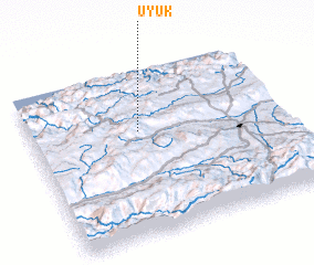 Places with similar names to Üyük, Turkey ::
Disclaimer :: Information on this page comes without warranty of any kind |
||
|
Where is Üyük? Elevation and coordinates ::
Latitude (lat): 41°38'0"N Longitude (lon): 33°26'0"E
Elevation (approx.): 1093m (map arrows pan, magnifying glasses zoom) |
||
|
Visiting Üyük? Hotel/Accommodation ::
Book a hotel in Üyük Travel Guide ::
Buy a travel guide for Turkey rental cars ::
car rental offers GPS waypoint ::
download a GPX waypoint (PoI) of Üyük for your GPS receiver
|
||