|
search place name
|
||
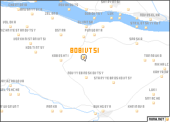
Bobivtsi (Chernivetsʼka Oblastʼ, Ukraine)Bobivtsi is a town in the Chernivetsʼka Oblastʼ region of Ukraine. An overview map of the region around Bobivtsi is displayed below.
regional and 3d topo map of Bobivtsi, Ukraine ::
Bobivtsi airports ::
The nearest airport is SCV - Suceava Stefan Cel Mare, located 80.7 km south east of Bobivtsi.
Other airports nearby include IAS - Iasi (188.1 km south east), LWO - Lvov Lviv Intl (214.1 km north west), BCM - Bacau (214.3 km south east), TGM - Tirgu Mures Vidrasau (222.2 km south west), Nearby towns ::
Novyye Broskovtsy (3.5km south) //
Drachintsi (5.3km north) //
Kabeshti (3.6km west) //
Fundoaya (5.9km north) //
Glinitsa (7.6km north) //
Staryye Broskovtsy (6.2km south east) //
Ostra (6.8km north west) //
Korostovat (8.0km north) //
[all distances 'as the bird flies' and approximate] 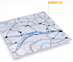
Disclaimer :: Information on this page comes without warranty of any kind |
||
|
Where is Bobivtsi? Elevation and coordinates ::
Latitude (lat): 48°15'54"N Longitude (lon): 25°41'54"E
Elevation (approx.): 224m (map arrows pan, magnifying glasses zoom) |
||
|
Visiting Bobivtsi? Hotel/Accommodation ::
Book a hotel in Bobivtsi Travel Guide ::
Buy a travel guide for Ukraine rental cars ::
car rental offers GPS waypoint ::
download a GPX waypoint (PoI) of Bobivtsi for your GPS receiver
|
||