|
search place name
|
||
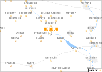
Medova (Ukraine)Medova is a town in Ukraine. An overview map of the region around Medova is displayed below.
regional and 3d topo map of Medova, Ukraine ::
Medova airports ::
The nearest airport is LWO - Lvov Lviv Intl, located 96.1 km west of Medova.
Other airports nearby include SCV - Suceava Stefan Cel Mare (221.7 km south east), BAY - Baia Mare Tautii Magheraus (245.1 km south west), Nearby towns ::
Kaplinʼtse (1.9km north) //
Zlochuvka (3.7km north) //
Vymysluvka (2.4km west) //
Budilov (3.0km south east) //
Olesino (3.0km south west) //
Plaucha Velʼka (5.7km north) //
Malaya Plavucha (5.7km north) //
Glinnaya (6.1km north west) //
Taurov (4.8km east) //
Velikaya Plavucha (7.4km north) //
Krasna (7.8km north) //
Tsetsory (8.8km north east) //
[all distances 'as the bird flies' and approximate]  Places with similar names to Medova, Ukraine ::
// Meadview (US)
// Meadow View (US)
// Meadowview (US)
// Meadowview (US)
// Meadowview (US)
// Mataphao (PH)
// Mituva (LT)
// Motovo (BA)
// Medovo (BG)
// Metofu (RO)
Disclaimer :: Information on this page comes without warranty of any kind |
||
|
Where is Medova? Elevation and coordinates ::
Latitude (lat): 49°32'0"N Longitude (lon): 25°13'0"E
Elevation (approx.): 357m (map arrows pan, magnifying glasses zoom) |
||
|
Visiting Medova? Hotel/Accommodation ::
Book a hotel in Medova Travel Guide ::
Buy a travel guide for Ukraine rental cars ::
car rental offers GPS waypoint ::
download a GPX waypoint (PoI) of Medova for your GPS receiver
|
||