|
search place name
|
||
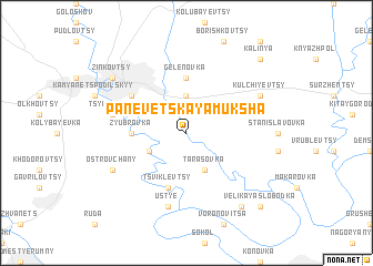
Panevetskaya Muksha (Ukraine)Panevetskaya Muksha is a town in Ukraine. An overview map of the region around Panevetskaya Muksha is displayed below.
regional and 3d topo map of Panevetskaya Muksha, Ukraine ::
Panevetskaya Muksha airports ::
The nearest airport is SCV - Suceava Stefan Cel Mare, located 107.4 km south of Panevetskaya Muksha.
Other airports nearby include IAS - Iasi (177.3 km south east), Nearby towns ::
Kulʼchiyevskaya Slobodka (3.7km north) //
Verkhniye Panovtsy (3.1km south west) //
Tarasovka (3.9km south) //
Zyubrovka (3.7km west) //
Gelenovka (5.6km north) //
Tsviklevtsy (5.7km south) //
Zhovtnevoye (5.2km north west) //
Ustʼye (7.5km south) //
Tsybulevka (5.2km west) //
Ostrovchany (6.1km south west) //
Kulʼchiyevtsy (6.1km north east) //
Slobodka Mukshanskaya (8.3km south east) //
Zinʼkovtsy (7.4km north west) //
Velikaya Slobodka (8.9km south east) //
Kalinya (8.9km north east) //
[all distances 'as the bird flies' and approximate] 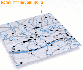 Places with similar names to Panevetskaya Muksha, Ukraine :: Disclaimer :: Information on this page comes without warranty of any kind |
||
|
Where is Panevetskaya Muksha? Elevation and coordinates ::
Latitude (lat): 48°38'0"N Longitude (lon): 26°39'0"E
Elevation (approx.): 213m (map arrows pan, magnifying glasses zoom) |
||
|
Visiting Panevetskaya Muksha? Hotel/Accommodation ::
Book a hotel in Panevetskaya Muksha Travel Guide ::
Buy a travel guide for Ukraine rental cars ::
car rental offers GPS waypoint ::
download a GPX waypoint (PoI) of Panevetskaya Muksha for your GPS receiver
|
||